|
SUSTAINABLE DEEP SEA OIL EXPLORATION
|
|
|
EXPLORATION METHODS
The days where oil was visible from seepage are long gone. Most oil exploration depends on highly sophisticated technology to detect and determine the extent of these deposits using exploration geophysics. Areas thought to contain hydrocarbons are initially subjected to a gravity survey, magnetic survey, passive seismic or regional seismic reflection surveys to detect large-scale features of the sub-surface geology. Features of interest (known as leads) are subjected to more detailed seismic surveys which work on the principle of the time it takes for reflected sound waves to travel through matter (rock) of varying densities and using the process of depth conversion to create a profile of the substructure. Finally, when a prospect has been identified and evaluated and passes the oil company's selection criteria, an exploration well is drilled in an attempt to conclusively determine the presence or absence of oil or gas.
HIGH RISK
Hydrocarbon exploration is a high risk investment and risk assessment is paramount for successful exploration portfolio management. Exploration risk is a difficult concept and is usually defined by assigning confidence to the presence of five imperative geological factors. This confidence is based on data and/or models and is usually mapped on Common Risk Segment Maps (CRS Maps). High confidence in the presence of imperative geological factors is usually colored green and low confidence colored red. Therefore these maps are also called Traffic Light Maps, while the full procedure is often referred to as Play Fairway Analysis. The aim of such procedures is to force the geologist to objectively assess all different geological factors. Furthermore it results in simple maps that can be understood by non-geologists and managers to base exploration decisions on.
SEISMOLOGICAL SURVEY
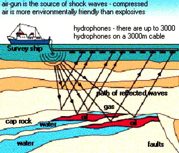
Most commonly, seismology is
used to locate deposits. Shock waves that pass through hidden rock layers and interpreting the waves that are reflected back to the surface.
REDUCING THE COST OF EXPLORATION
Automation is the key to reducing the cost of finding oil deposits. One way of doing this is to employ robots. Robot ships are now possible due to improvements in autopilots linked to COLREGs compliant navigation. Such a system is being developed for a low maintenance hull that is powered by a patent mix of energy harnessed from nature.
A consortium of British engineers are working on providing such a prototype ship in the next few years that is suitable for oil exploration. Funding is difficult to secure for such projects and risk share partners are being sought. The groundwork for such a ship is being laid in the testing of the Bluefish model, the build of which is a current feature. It is hoped that sufficient interest from corporations and governments might secure testing of this hull from 2014. A Bluefish hull variation is ideal for equipping with hydrophones as a 100-200 meter array with between 50-100 hydrophones.
Given that the ship is a robot, it may cruise 24/7 on a predetermined mission with instant feedback of findings to a shore based operations room. Once oil is located, the mission may be reprogrammed, or placed into drone mode. Using a small fleet of such robot survey ships, the time of survey may be reduced, along with the manning and operational overheads.
PERSISTENT MONITORING
Robot ships may also be used for routine monitoring duties as a preventative measure to guard against oil leaks, the clues for which are usually there if one is looking for them with the right equipment.
OIL OWNERSHIP
Petroleum resources are typically owned by the government of the host country. In the USA most onshore (land) oil and gas rights (OGM) are owned by private individuals, in which case oil companies must negotiate terms for a lease of these rights with the individual who owns the OGM. Sometimes this is not the same person who owns the land surface. In most nations the government issues licences to explore, develop and produce its oil and gas resources, which are typically administered by the oil ministry. There are several different types of licence. Oil companies often operate in joint ventures to spread the risk; one of the companies in the partnership is designated the operator who actually supervises the work.
Service contract - This is when an oil company acts as a contractor for the host government, being paid to produce the hydrocarbons.
MAGADISHU, SOMALIA 6 AUGUST 2013
CONTACTS
The Norwegian Oil Spill Control Association P.O.
Box 125 Tel.:
+47 33 03 48 25
LINKS
http://abcnews.go.com/International/wireStory/somalia-signs-oil-exploration-deal-uk-firm-19881292 http://en.wikipedia.org/wiki/Hydrocarbon_exploration http://www.oceanologyinternational.com http://www.maritimeindustries.org/Events/Indonesia-Maritime-Expo-2013/11190 http://www.maritimeindustries.org/Events/Oceanology-International-China-2013/9255 http://www.bp.com/en/global/corporate/sustainability.html http://science.howstuffworks.com/environmental/energy/oil-drilling2.htm http://in2eastafrica.net/kenya-shifts-gears-on-deep-sea-oil-exploration-as-interest-peaks/ http://www.bp.com/en/global/corporate/gulf-of-mexico-restoration.html http://www.foxoildrilling.com/videos.html http://www.maritimexpo.co.id/supporting-partners http://www.inamarine-exhibition.net/
|
|
|
This
website is Copyright © 2013 Bluebird Marine Systems Ltd.
The names Bluebird, Solar Navigator™,Blueplanet Ecostar BE3™, Utopia Tristar™
and the blue bird in flight
|
