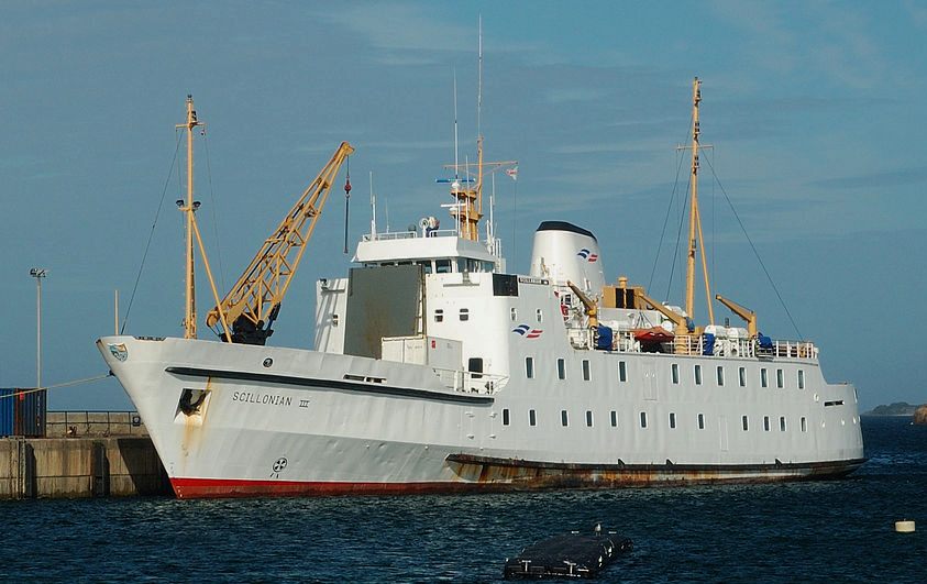
MBA - FISH TRACKING SURVEY, PLYMOUTH, SCILLY ISLES

Marine Biological Association and Marine Protected Areas, mission to find fish using autonomous endurance vessels


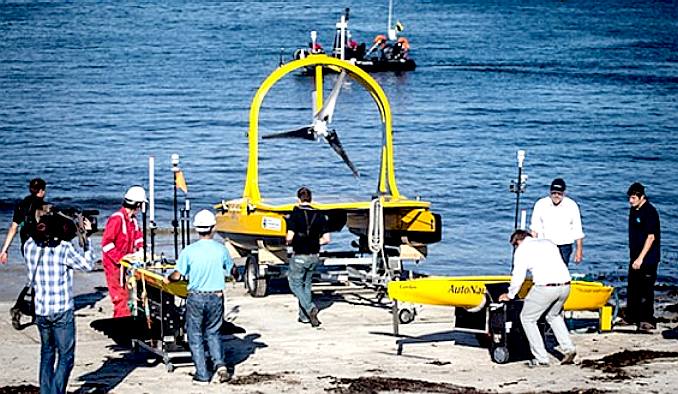
Seen in the centre of this picture, the C-Enduro is a wind generator and solar panel powered catamaran funded in May of 2014, along with the Autonaut (right), a wave propelled design. The two prototypes have been designed and built as part of a government-backed Small Business Research Initiative (SBRI) with the basic aim of developing ocean-going robotic vehicles capable of sustained marine research over long periods. Co-funding was provided by the Natural Environment Research Council (NERC), the Technology Strategy Board (TSB) and the Defence Science & Technology Laboratory (Dstl)


Designs for the vehicles were originally chosen by a panel of scientific and technical experts prior to development in association with the NOC’s Marine Autonomous & Robotic Systems (MARS) team. They have since successfully undergone rigorous capability trials in Portsmouth Harbour and off the coast of Oban in Scotland. The robots have been developed by Hampshire companies ASV and MOST (AV) in collaboration with the National Oceanography Centre at Southampton. The wave powered vessel on the left is a Waveglider from Liquid Robotics. The three autonomous vehicles – AutoNaut, C-Enduro and the SV3 Waveglider – are carrying a range of sensors to collect additional data on the physical properties of the ocean, such as water temperature and salinity.


DAILY MAIL - 6 NOVEMBER 2014


The ocean-going drone boats that will scour the seas for months tracking delicious rare fish - and could lead to fuel free ships.

> Will help protected species and spread new light on breeding patterns
> Biggest project of its in ever carried out the UK 
> Plaice, sole, brill, and rays are being tracked 
> Wind, solar and wave power system could be scaled up for ships


Ocean-going robots are being used in a pioneering science project off the coast of Britain. Three innovative machines are tracking tagged fish and monitoring the sea. The robo scouts can remain at sea for months using wind, solar and wave power.

The project is the biggest of its kind ever in Britain and could herald a new era in ocean exploration as the vehicles are designed to operate remotely across the oceans for months using wind, solar and wave power.

Scientists from the Marine Biological Association (MBA) in Plymouth, Devon, also hope the experiment will shed light on the private lives of some fish species and show whether new protected areas are effective in conserving stocks.

'This is a pioneering project,' said Guy Baker. 'We have not been able to follow fish in real time at day and night before.' Remote sensing cuts the cost of marine science at sea by freeing up research vessels manned by scientists, he said.

The wave-power technology behind AutoNaut could also lead to a revolution in marine transport, believes the man who developed the robot.

Although the drone ship is just 3.5 metres long, the technology could be scaled up for a ship, said Mike Poole, a director of MOST (Autonomous Vessels). That would save on fuel costs for ocean transport, he added.

AutoNaut, C-Enduro, also British-built, and American vessel SV3 Waveglider were launched yesterday from Queen Anneís Battery in Plymouth in what is the second phase of the Exploring Ocean Fronts project.

Last month five marine robots, including the wave-powered Devon craft, proved they could survive gales of up to 70mph as they travelled hundreds of miles gathering data in the Atlantic off the Isles of Scilly.


Scientists from the MBA and technologists from the National Oceanography Centre, which has twin sites in Southampton and Liverpool, are involved. Plymouth Marine Laboratory is providing support.

The three robot boats will spend about two weeks tracking 85 plaice, sole, brill, and rays caught and tagged by the MBA and released yesterday. 

Dr Stephen Cotterell, of the Marine Biological Association, is leading the project. This technology will give us a new dimension in our understanding of fish movements, residency and migrations in and around the marine protected areas off Plymouth. 

The second phase of the project is expected to last until mid-November and follows the highly successful first phase, which saw five marine robots travelling for hundreds of kilometres off the Isles of Scilly to collect ocean and meteorological data. 

The two-phase project is the largest deployment of marine autonomous systems ever seen in the UK and will provide valuable information about the shelf seas, marine life and the scope for autonomous vehicles in future research projects.


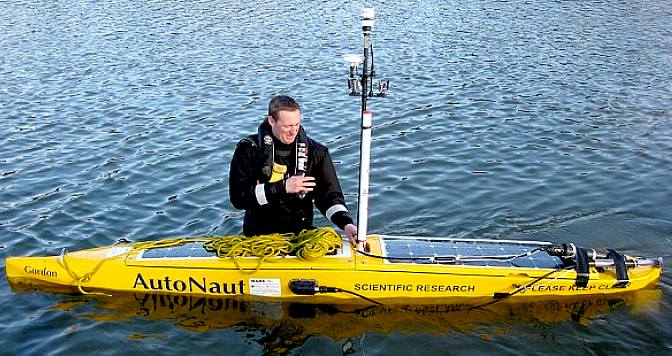
The AutoNaut is a fine entry and ended monohull that is powered by solar and wave energy. The solar panels power the onboard electronics, the hull is propelled by wave motion using foils. 


HOW IT WORKS - Using acoustic 'pingers', plaice, sole, brill, and rays are being tracked at sea by the ocean robots programmed to patrol a large area of the MPAs are a number of seabed listening stations which work in concert with the ocean robots.

The three autonomous vehicles – AutoNaut, C-Enduro and the SV3 Waveglider – are all carrying a range of sensors to collect additional data on the physical properties of the ocean, such as water temperature and salinity. On-board cameras will also capture valuable photographs and video footage of seabirds and other marine life. The three robot boats will spend about two weeks tracking 85 plaice, sole, brill, and rays caught and tagged by the MBA and released yesterday.


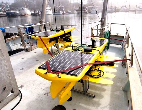
The AutoNaut is operated on behalf of the NOC by MOST (Autonomous Vessels) Ltd; C-Enduro was built and is operated on behalf of the NOC by ASV Ltd; and the NOC’s own SV3 Waveglider is being supported by its manufacturer (Liquid Robotics).


Liquid Robotics Waveglider is a solar and wave powered autonomous monohull that is simple and robust, save for the underwater fin assembly that might have been inspired by a Venetian blind or kite, as mush as a fish tail.


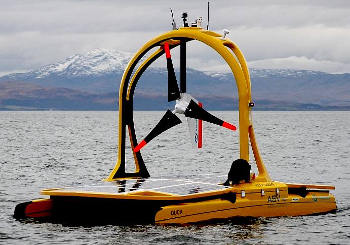
We will be most interested to learn of the energy generated by the Ampair wind turbine, where it is mounted so low. We'd like to contrast this with the loss of energy caused by shading of the solar decks. A far more logical solution is seen in the patent Bluefish ZCC design, where the turbines are mounted so as not to shade the solar wings, and may be moved higher to advantage a ship of the faster airstreams - and lowered in times of inclement weather, taking marine robotics to a new level.
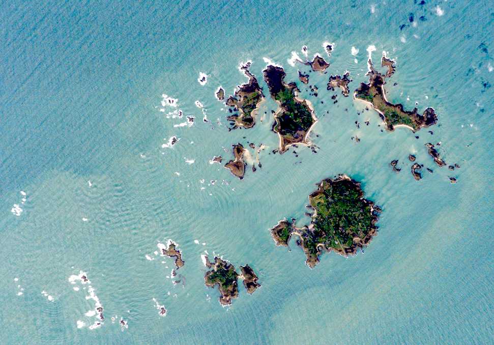
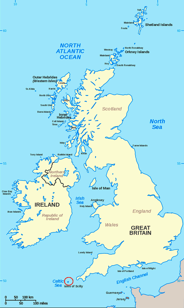


SCILLY ISLES


The Isles of Scilly are an archipelago off the southwestern tip of the Cornish peninsula of Great Britain.

Although the Isles of Scilly are still part of the ceremonial county of Cornwall, and some services have been combined with those of Cornwall, since 1890 the islands have had a separate local authority. Since the passing of the Isles of Scilly Order 1930, this authority has had the status of a county council and today is known as the Council of the Isles of Scilly. The adjective "Scillonian" is sometimes used for people or things related to the archipelago. The Duchy of Cornwall owns most of the freehold land on the islands. Tourism is a major part of the local economy, along with farming and agriculture. Natural England has designated the Isles of Scilly as National Character Area 158.


Satellite picture of the Scilly Isles taken by NASA


SCILLY ISLES - GEOGRAPHY

The Isles of Scilly form an archipelago of five inhabited islands and numerous other small rocky islets (around 140 in total) lying 45 km (28 mi) off Land's End. They are all composed of granite rock of early Permian age, an exposed part of the Cornubian batholith.

The islands' position produces a place of great contrast—the ameliorating effect of the sea, greatly influenced by the North Atlantic Current, means they rarely have frost or snow, which allows local farmers to grow flowers well ahead of those in mainland Britain. The chief agricultural product is cut flowers, mostly daffodils. Exposure to Atlantic winds also means that spectacular winter gales lash the islands from time to time. This is reflected in the landscape, most clearly seen on Tresco where the lush sub-tropical Abbey Gardens on the sheltered southern end of the island contrast with the low heather and bare rock sculpted by the wind on the exposed northern end.

As part of a 2002 marketing campaign, the plant conservation charity Plantlife chose sea thrift (Armeria maritima) as the "county flower" of the islands.


Island

Population
(Census 2001)

Area (km²)

Main settlement

St Mary's

1,666

6.29

Hugh Town

Tresco

180

2.97

New Grimsby

St Martin's (with White Island)

142

2.37

Higher Town

St Agnes (with Gugh)

73

1.48

Saint Agnes

Bryher (with Gweal)

92

1.32

Bryher

Samson

-(1)

0.38


Annet

 –

0.21


St. Helen's

 –

0.20


Teän

 –

0.16


Great Ganilly

 –

0.13


remaining 45 islets

 –

0.50


Isles of Scilly

2,153

16.03

Hugh Town


SCILLY ISLES - CLIMATE

The Isles of Scilly have a temperate Oceanic climate (Köppen climate classification Cfb), among the mildest and warmest climates in the United Kingdom. The average annual temperature is 11.8 °C (53.2 °F) in comparison to London, where it is 11.6 °C (52.9 °F). Winters are among the warmest in the country due to the moderating effects of the ocean. Summers are not as warm as on the mainland. They are one of the sunniest areas in the southwest with on average 7.6 hours per day in July. The lowest temperature ever recorded was −7.2 °C (19.0 °F) on 13 January 1987 and the highest was 30 °C (86.0 °F) on 16 August 1947. The maximum snowfall was 23 cm (9 in) on 12 January 1987. The Isles of Scilly, with fewer than 2 days of air frost per year (on average), are in the United States Department of Agriculture (USDA) Hardiness zone 10. This is the only UK domain which falls in this hardiness zone. Less than one day per year has a maximum air temperature above 30 °C (86 °F) (on average); the isles are in the American Horticultural Society (AHS) Heat Zone 1, which is the coolest.


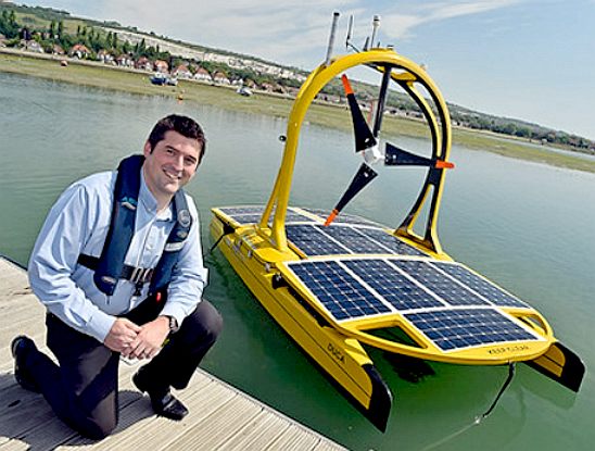
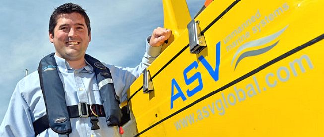
Managing Director of ASV Global, Dan Hook, poses with his company's C-Enduro catamaran. What is interesting is that this is a fairly sizeable craft that appear not to be able to comply with COLREGs. What then will happen in a case involving collision or loss of human life? The operators of unmanned vehicles are responsible for accidents that they may cause or of any failure to comply with maritime regulations, such as SOLAS.
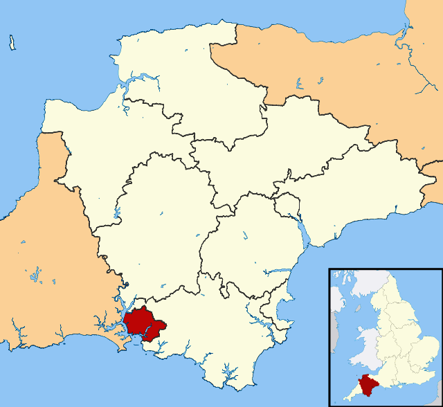


PLYMOUTH

Plymouth is a city and unitary authority area on the south coast of Devon, England, about 190 miles (310 km) south-west of London. It is situated between the mouths of the rivers Plym to the east and Tamar to the west, where they join Plymouth Sound.

Plymouth's early history extends to the Bronze Age, when a first settlement emerged at Mount Batten. This settlement continued as a trading post for the Roman Empire, until it was surpassed by the more prosperous village of Sutton, now called Plymouth. In 1620, the Pilgrim Fathers departed Plymouth for the New World and established Plymouth Colony – the second English settlement in what is now the United States of America. During the English Civil War the town was held by the Parliamentarians and was besieged between 1642 and 1646.


Prysten House, Finewell Street is the oldest property in Plymouth - 1498


Prysten House, Finewell Street is the oldest property in Plymouth, dating from 1498


Throughout the Industrial Revolution, Plymouth grew as a commercial shipping port, handling imports and passengers from the Americas, and exporting local minerals (tin, copper, lime, china clay and arsenic) while the neighbouring town of Devonport became a strategic Royal Naval shipbuilding and dockyard town. In 1914 three neighbouring independent towns, viz., the county borough of Plymouth, the county borough of Devonport, and the urban district of East Stonehouse were merged to form a single County Borough. The combined town took the name of Plymouth which, in 1928, achieved city status. The city's naval importance later led to its targeting and partial destruction during World War II, an act known as the Plymouth Blitz. After the war the city centre was completely rebuilt and subsequent expansion led to the incorporation of Plympton and Plymstock along with other outlying suburbs in 1967.

Today the city is home to around 250,000 people, making it the 27th most populous built-up area in England and Wales. It is governed locally by Plymouth City Council and is represented nationally by three MPs. Plymouth's economy remains strongly influenced by shipbuilding and seafaring including ferry links to France (Roscoff) and Spain (Santander), but has tended toward a service-based economy since the 1990s. It has the ninth largest university in the United Kingdom by number of students, the University of Plymouth, and the largest operational naval base in Western Europe – HMNB Devonport.


Location map of Devon in the United Kingdom, with Plymouth shown in red on the expanded section.


GEOGRAPHY


Plymouth lies between the River Plym to the east and the River Tamar to the west; both rivers flow into the natural harbour of Plymouth Sound. Since 1967, the unitary authority of Plymouth has included the, once independent, towns of Plympton and Plymstock which lie along the east of the River Plym. The River Tamar forms the county boundary between Devon and Cornwall and its estuary forms the Hamoaze on which is sited Devonport Dockyard.

The River Plym, which flows off Dartmoor to the north-east, forms a smaller estuary to the east of the city called Cattewater. Plymouth Sound is protected from the sea by the Plymouth Breakwater, in use since 1814. In the Sound is Drake's Island which is seen from Plymouth Hoe, a flat public area on top of limestone cliffs. The Unitary Authority of Plymouth is 30.8 square miles (80 km2), but the city of Plymouth, as cited from Plymouth City Council, is 30.61 square miles (79.3 km2). The topography rises from sea level to a height, at Roborough, of about 509 feet (155 m) above Ordnance Datum (AOD).


RMV Scillonian III docked at St Mary's Harbour


RMV Scillonian III docked at St Mary's Harbour, Scilly Isles


Geologically, Plymouth has a mixture of limestone, Devonian slate, granite and Middle Devonian limestone. Plymouth Sound, Shores and Cliffs is a Site of Special Scientific Interest, because of its geology. The bulk of the city is built upon Upper Devonian slates and shales and the headlands at the entrance to Plymouth Sound are formed of Lower Devonian slates, which can withstand the power of the sea.

A band of Middle Devonian limestone runs west to east from Cremyll to Plymstock including the Hoe. Local limestone may be seen in numerous buildings, walls and pavements throughout Plymouth. To the north and north east of the city is the granite mass of Dartmoor; the granite was mined and exported via Plymouth. Rocks brought down the Tamar from Dartmoor include ores containing tin, copper, tungsten, lead and other minerals. There is evidence that the middle Devonian limestone belt at the south edge of Plymouth and in Plymstock was quarried at West Hoe, Cattedown and Radford.


Map of the United Kingdom


Map of the United Kingdom and Ireland, showing the Scilly Isles ringed in red.


The Marine Biological Association


MBA CONTACTS


The Marine Biological Association of the United Kingdom
The Laboratory
Citadel Hill
Plymouth
Devon, PL1 2PB


Telephone: +44 (0)1752 633207
Fax: +44 (0)1752 633102
Email: sec@mba.ac.uk


Dan Hook rests on the C-Enduro hull. Note the stainless steel quick release catches that (presumably) allow the dismasting of the wind turbine and navigation electronic sensors.


PORTCHESTER SEA TRIALS, JANUARY 2014 - The trials, which were attended by the National Oceanography Centre (NOC) and Royal Navy personnel, saw the C-Enduro operate autonomously and follow various courses set out by ASV’s control system. The highlight of the two day event came when the vehicle followed a course spelling out ‘ASV’. The C-Enduro brings a step change in oceanographic data collection, with an endurance of up to three months enabled by its environmentally friendly power structure the vehicle can support up to 500 watts of payload power. The applications for the vehicle are vast, ranging from marine environmental surveying to security and defence roles. The robust vehicle design utilises state of the art technologies from the consortium and was designed to operate in coastal or open ocean weather conditions, currents and sea states.

The vehicle was developed under the UK Government-backed Small Business Research Initiative (SBRI). The team behind the development of the LEMUSV, led by ASV, includes Hyperdrive Ltd who investigated motor options and power management systems and Cranfield University who have conducted research into collision avoidance technologies. The C-Enduro vehicle centres on a ‘three pillar’ energy system providing a flexible and fault tolerant solution to energy supply. Having researched and trialled various energy sources the team selected solar panels, a wind generator and a lightweight diesel generator. Detailed calculations and tests show that this selection, combined with efficient power management and command and control systems packaged in a rugged self-righting vehicle, provides the greatest likelihood of meeting the performance requirements.


Formed in 1998 ASV provides rugged, reliable and effective unmanned marine systems using cutting edge technology. ASV is based near Portsmouth in the United Kingdom. Contact: Sarah Dyer - Sales and Marketing Assistant  sarah.dyer@asvglobal.com


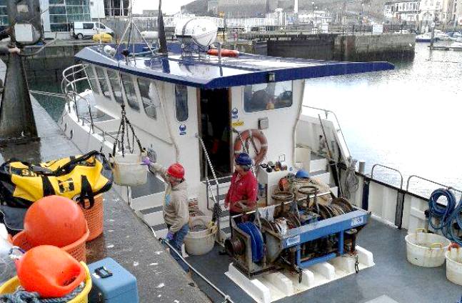
The MBS's Sepia being loaded with equipment. A vessel like this will not fare well in the persistent data collection stakes, but is needed to catch and tag the fish that the robot trackers will be looking for. It remains to be seen how well such a system will work. Other uses for unmanned tracking is the hunt for foreign submarines in sovereign waters or other strategic choke points, as per the SeaNet™ and SeaWolf™ methods. See Patent specification.


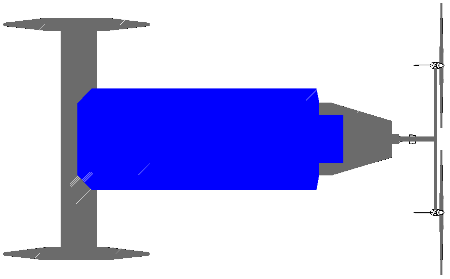
A SEAVAX DRONE - This is a raw proposal for a robot ship that is designed to vacuum up plastic waste from the ocean based on the Bluefish ZCC concept. The vessel is solar and wind powered - and shares component with other variants. The front end (left) is modified so that there is a wide scoop area, into which plastic waste is funneled as the ship moves forward. The waste is pumped into a large holding bay after treatment, then stored until it can be off-loaded. The rear of the ship (right) carries two large wind turbines that generate electricity in combination with deck mounted solar panels (shown here in blue) to power the onboard processing machinery. The system can be semi-autonomous, such that in robot mode they alert HQ to any potential problems and share data as to progress for backers. A whole cleanup mission can be controlled from land, with visuals and data streams. A SeaVax would operate using a search program called SeaNet, that would need to be modified for this specific function.


http://www.mbai.org.in/     http://www.sams.ac.uk/


PLASTIC OCEANS


LINKS & REFERENCE


Wikipedia Marine_Biological_Association_of_the_United_Kingdom

Maritime Journal UK funded-ocean robot development

maritime journal autonomous asv robots set sail on uk survey

Marine Link MBA Marine Biological Association fish tracking mission

Wikipedia Scottish_Association_for_Marine_Science

Marine Biological Association of India

Seaworld South African Association Marine Resarch

BSHS travel guide marine biological association plymouth

Daily Mail The-ocean-going-drone-boat-scour-seas-months-tracking-rare-fish-lead-fuel-free-ships

NOC projects exploring-ocean-fronts c-enduro

Maritime Industries ASV LEMUSV long endurance marine unmanned surface vehicle

Wikipedia Isles_of_Scilly

Wikipedia Plymouth

http://en.wikipedia.org/wiki/Plymouth

http://en.wikipedia.org/wiki/Isles_of_Scilly

http://www.maritimeindustries.org/Member-News/long-endurance-marine-unmanned-surface-vehicle-lemusv

http://www.sams.ac.uk/

http://www.bshs.org.uk/travel-guide/marine-biological-association-plymouth-england

http://www.seaworld.org.za/saambr

http://www.mbai.org.in/

http://en.wikipedia.org/wiki/Scottish_Association_for_Marine_Science

http://en.wikipedia.org/wiki/Marine_Biological_Association_of_the_United_Kingdom

http://www.marinelink.com/news/vehicles-tracking-mission380200.aspx

http://noc.ac.uk/research-at-sea/nmfss/mars

http://www.nerc.ac.uk/press/releases/2014/26-oceanrobots/

http://www.nerc.ac.uk/

http://www.pml.ac.uk/

http://www.ukmarinealliance.com/

http://projects.noc.ac.uk/exploring-ocean-fronts/c-enduro

http://noc.ac.uk/

https://sbri.innovateuk.org/

http://www.southampton.ac.uk/

http://www.autonautusv.com/

http://www.maritimejournal.com/news101/marine-civils/hydrographic-survey/uk-funded-ocean-robot-development

http://www.asvglobal.com/


A humpback whale stikes a blow for anti whaling - The $Billion Dollar Whale movie


Blueplanet Universal is looking to turn the Kulo Luna story into a script for a major film release, along the lines of Free Willy, Saving Luna, Big Miracle and Dolphin Tale.


ACIDIFICATION - ADRIATIC - ARCTIC - ATLANTIC - BALTIC - BAY BENGAL - BERING - CARIBBEAN - CORAL - EAST CHINA

ENGLISH CH - GOC - GULF GUINEA - GULF MEXICO - INDIAN - IOC - IRC - MEDITERRANEAN - NORTH SEA - PACIFIC - PERSIAN GULF - SEA JAPAN

STH CHINA - PLASTIC - PLANKTON - PLASTIC OCEANS - SEA LEVEL RISE - UNCLOS - UNEP WOC - WWF

AMAZON - BURIGANGA - CITARUM - CONGO - CUYAHOGA - GANGES - IRTYSH - JORDAN  - LENA - MANTANZA-RIACHUELO

MARILAO - MEKONG - MISSISSIPPI - NIGER - NILE - PARANA - PASIG - SARNO - THAMES - YANGTZE - YAMUNA - YELLOW


This website is Copyright © 2015 Bluebird Marine Systems Ltd.   The names Bluebird, Bluefish™, Miss Ocean™, SeaNet™, SeaVax™ and the blue bird in flight  Bluebird trademark legend, blue bird in flight logo logo are  trademarks. The color blue is an essential element of the mark.