|
The International Hydrographic Organization (IHO) is the inter-governmental organisation representing the hydrographic community. It enjoys observer status at the United Nations where it is the recognised competent authority on hydrographic surveying and nautical charting. When referring to hydrography and nautical charting in Conventions and similar Instruments, it is the IHO standards and specifications that are normally used.
HISTORY
The IHO was established in 1921 as the International Hydrographic Bureau (IHB). The present name was adopted in 1970 as part of a new international Convention on the IHO adopted by the then member nations. The former name International Hydrographic Bureau was retained to describe the IHO secretariat comprising three elected Directors and a small staff at the Organization's headquarters in Monaco.
During the 19th century, many maritime nations established hydrographic offices to provide means for improving the navigation of naval and merchant vessels by providing nautical publications, nautical charts, and other navigational services. There were substantial differences in hydrographic procedures charts, and publications. In 1889, an International Marine Conference was held at Washington, D.C., and it was proposed to establish a "permanent international commission." Similar proposals were made at the sessions of the International Congress of Navigation held at St. Petersburg in 1908 and again in 1912.
In 1919 the hydrographers of Great Britain and France cooperated in taking the necessary steps to convene an international conference of hydrographers. London was selected as the most suitable place for this conference, and on 24 July 1919, the First International Conference opened, attended by the hydrographers of 24 nations. The object of the conference was "To consider the advisability of all maritime nations adopting similar methods in preparation, construction, and production of their charts and all hydrographic publications; of rendering the results in the most convenient form to enable them to be readily used; of instituting a prompt system of mutual exchange of hydrographic information between all countries; and of providing an opportunity to consultations and discussions to be carried out on hydrographic subjects generally by the hydrographic experts of the world." This is still the major purpose of IHO.
As a result of the conference, a permanent organization was formed and statutes for its operations were prepared. The IHB, now the IHO, began its activities in 1921 with 18 nations as members. The Principality of Monaco was selected as the seat of the Organization as a result of the generous offer of Albert I, Prince of Monaco to provide suitable accommodations for the Bureau in the Principality.
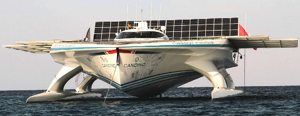
Neither
the IOH, nor the
UK, owns or operates any zero pollution hydrographic ships. The
Swiss are therefore significantly advanced and leading the world by
example. Geneva
University is working with the PlanetSolar vessel to monitor the
Gulf Stream. Other expeditions are planned, the next to Rio
de Janeiro to monitor the effect of Saharan dust on the
oceans.
FUNCTIONS
The principal work undertaken by the IHO is:
* To bring about a close and permanent association between national hydrographic offices.
* To study matters relating to hydrography and allied sciences and techniques.
* To further the exchange of nautical charts and documents between hydrographic officers of member governments.
*
To tender guidance and advice upon request, in particular to countries expanding their hydrographic service.
* To encourage coordination of hydrographic surveys with relevant oceanographic activities.
* To extend and facilitate the application of oceanographic knowledge for the benefit of navigators.
* To cooperate with international organizations and scientific institutions which have related objectives.
The IHO develops hydrographic and nautical charting standards to be agreed upon by its Member States. All Member States then follow those standards in their surveys, nautical charts, and publications. The almost universal use of the standards means that the products and services from the world's hydrographic and oceanographic offices are increasingly consistent and recognisable for all seafarers and for other users. Much has been done in the field of standardisation since the Bureau (now the IHO) was founded.
PUBLICATIONS
Most IHO publications, including the standards, guidelines and associated documents such as the International Hydrographic Review, International Hydrographic Bulletin, the Hydrographic Dictionary and the Year book are available to the general public free from the IHO website.
The IHO publishes the international standards related to charting and hydrography, including S-57 IHO Transfer Standard for Digital Hydrographic Data, the encoding standard that is used primarily for electronic navigational charts. The IHO has introduced (January 2010) a new, contemporary hydrographic geospatial standard for modelling marine data and information, known as S-100. S-100 and any dependent product specifications are underpinned by an on-line registry available via the IHO website. S-100 is aligned with the ISO 19100 series of geographic standards, thereby making it fully compatible with contemporary geospatial data standards. Because S-100 is based on ISO 19100, it can be used by other data providers for their maritime related (non-hydrographic) data and information. This is already beginning to occur (2011) with various would-be data providers preparing themselves for the advent of the E-Navigation concept currently under active discussion in the UN International Maritime Organisation (IMO).
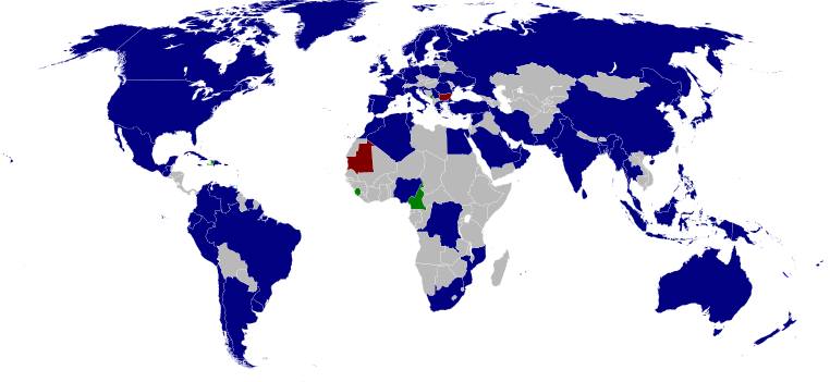
Map
of the world showing the member states in blue
MEMBER STATES
The following countries are members of the IHO:
Algeria
Argentina
Australia
Bahrain
Bangladesh
Belgium
Brazil
Canada
Cameroon
Chile
China
Colombia
Democratic Republic of Congo (suspended)
Croatia
Cuba
Cyprus
Denmark
Dominican Republic (suspended)
Ecuador
Egypt
Estonia
Fiji
Finland
France
Germany
Greece
Guatemala
Iceland
India
Indonesia
Iran
Ireland
Italy
Jamaica
Japan
Democratic People's Republic of Korea
Republic of Korea
Kuwait
Latvia
Malaysia
Mauritius
Mexico
Monaco
Morocco
Mozambique
Myanmar
Netherlands
New Zealand
Nigeria
Norway
Oman
Pakistan
Papua New Guinea
Peru
Philippines
Poland
Portugal
Qatar
Romania
Russian Federation
Saudi Arabia
Serbia (suspended)
Singapore
Slovenia
South Africa
Spain
Sri Lanka
Suriname
Sweden
Syrian Arab Republic
Thailand
Tonga
Trinidad and Tobago
Tunisia
Turkey
Ukraine
United Arab Emirates
United Kingdom
Uruguay
United States (NOAA, CNMOC, NGA)
Venezuela
LINKS
http://www.maritimejournal.com/news101/industry-news/ukho-appoints-new-national-hydrographer http://en.wikipedia.org/wiki/United_Kingdom_Hydrographic_Office http://www.ths.org.uk http://www.spri.cam.ac.uk/friends/committee/ http://www.thefutureofnavigation.com/ten_steps.aspx http://www.quaynote.com/ankiti/www/?code=ecdis13&f=programme
Wiki
United_Kingdom_Hydrographic_Office
http://www.iho.int/srv1/
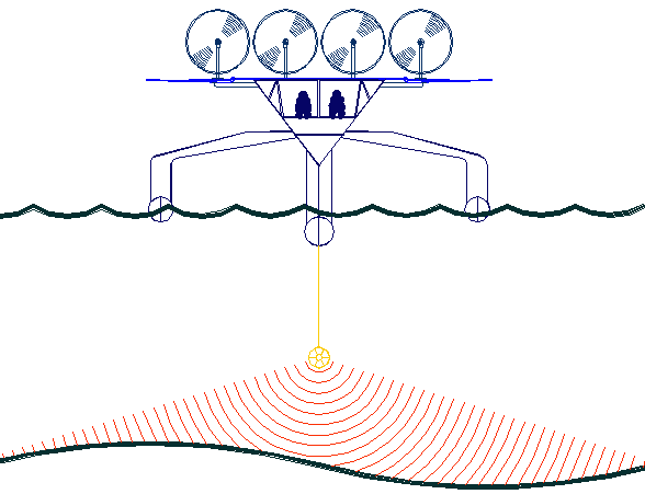
The
key to accurate hydrographic mapping is continuous monitoring,
for which the SNAV
platform, presently under development, is a robotic ocean workhorse with a
maximun speed of 18 knots. Based on a stable
SWASH
hull this design is under development in the United Kingdom. This robot
ship will use no diesel fuel to monitor the oceans autonomously (COLREGS
compliant) at relatively high
speeds of between 7-10 knots, 24/7 and 365 days a year - only possible with the revolutionary (patent) energy harvesting system. The
hullform is ideal for automatic release and recovery of ROVs
or towed arrays, alternating between drone and fully autonomous modes.
International development partners are welcome. This vessel
pays for itself in fuel saved every ten years.
|