|
|
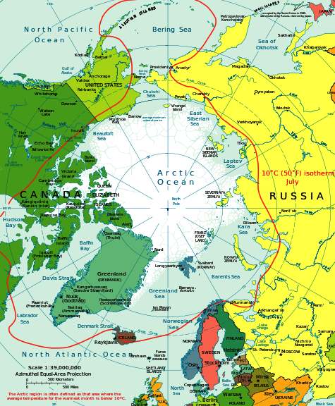
THE BERING SEA and ALEUTIAN ISLANDS
|
|||||||||||||||||||||||||||||||||||||||||||||||||||||||||||||||||||||||||||||||||||||||||||||||||||||||||||||||||||||||||||||||||||||||||||
|
Map of the Bering Sea and Aleutian Islands
THE BERING SEA
The Bering Sea is a marginal sea of the Pacific Ocean. It comprises a deep water basin, which then rises through a narrow slope into the shallower water above the continental shelves.
THE BERING STRAIGHT
The Bering Strait (Russian: Берингов пролив, Beringov proliv, Yupik: Imakpik) is a strait 82 kilometres (51 mi; 44 nmi) wide at its narrowest point, between Cape Dezhnev, Chukchi Peninsula, Russia, the easternmost point (169° 43' W) of the Asian continent and Cape Prince of Wales, Alaska, USA, the westernmost point (168° 05' W) of the North American continent. Named after Vitus Bering, a Russian explorer born in
Denmark, it lies slightly south of the polar circle at approximately 65° 40' N latitude, with the present US-Russia east-west boundary, agreed to only by the USA, at 168° 58' 37" W.
The Humpback whale is one of the most prolific cetaceans to frequent these rich feeding grounds, also one of the most playful. Broaching is a spectacular treat for visitors. Kulo Luna is shown above as a calf.
BIODIVERSITY
The sea supports many endangered whale species including Bowhead Whale,
Blue
Whale, Fin Whale, Sei Whale, Humpback
Whale, Sperm Whale and the rarest in the world, the North Pacific
Right
Whale. Other marine mammals include walrus, Steller Sea Lion, Northern Fur
Seal, Beluga, Orca and
polar
bear.
THE ALEUTIAN ISLANDS
The Aleutian Islands (/əˈl(j)uːʃən/; possibly from Chukchi aliat, "island") are a chain of 14 large volcanic islands and 55 smaller ones belonging to both the United States and Russia. They form part of the Aleutian Arc in the Northern Pacific Ocean, occupying an area of 6,821 sq mi (17,666 km²) and extending about 1,200 mi (1,900 km) westward from the Alaska Peninsula toward the Kamchatka Peninsula in Russia, and mark a dividing line between the Bering Sea to the north and the Pacific Ocean to the south. Crossing longitude 180°, at which point east and west longitude end, the archipelago contains both the westernmost part of the United States by longitude (Amatignak Island) and the easternmost by longitude (Semisopochnoi Island). The westernmost U.S. island in real terms, however, is Attu Island, west of which runs the International Date Line. While nearly all the archipelago is part of Alaska and is usually considered as being in the "Alaskan Bush", at the extreme western end, the small, geologically related Commander Islands belong to Russia.
Unalaska
The islands, known before 1867 as the
Catherine Archipelago, comprise five groups (east to west):
Chapter 7 - ARCTIC CIRCLE
The
Arctic region is a vast region of icy seas and snow covered lands where the sun
does not set in summer, nor rise in winter. This desolate expanse is home
to hardy Eskimos, a race of superbly adapted nomadic aboriginal flesh
eaters, polar bears and seals. Around the North Pole, the waters are
permanent sheet or pack ice. Further south, the ice melts in summer, which
melt is gradually creeping north as the earth is warming. In winter
Eskimos shelter in igloos, in summer in animal skin tents.
They live on a mixture of fish,
seals and the occasional whale, when meat
is plentiful. Their clothes are fashioned from furs and they are skilled
artisans. Further south at the rim of the
Bering Sea, the Aleutian Islands are the feeding grounds for the humpback
whale, giant rorqual acrobats and accomplished vocalists. Humpback whales
have strange
white patch splashes on their unusually large front flippers and body
undersides, presumably as camouflage. The flippers are roughly a third of
body length and irregular shaped with round knob like projections on their
large upper and lower jaws, and long head. Humpbacks are fond of leaping
out of the water in a display called broaching, when their deeply notched
tail flukes are a distinguishing feature. Humpbacks have widely spaced throat grooves that expand in billows fashion to allow them to intake large volumes of water. They have no teeth, but feed by filling their mouths with water containing zooplankton, krill and fish, then filtering out the water, expelling it through flexible baleen strips made of keratin, a strong fingernail like substance, which hang in closely packed rows, curtain fashion from the upper jaw. The small animals trapped in their mouths by this sieving process are then swallowed. Groups of Humpbacks hunt in teams, swimming in circles around a fish shoal making bait balls in a technique known as bubble net feeding. A dozen or so whales work together to harvest the bonanza of shoals. This requires a high degree of intelligence, good timing and communication; the water equivalent of pack hunting. The lead whale dives first and
locates a shoal, then swims around it in a circle releasing air bubbles to
create a theoretical spiral curtain. The other whales join the leader from
underneath in a tight formation, singing to confuse the fish. The fish are
then panicked to swim ahead reluctant to enter the bubble curtain barrier,
so swim upwards, followed by the whales who all surface mouths agape to
net a concentrated fish mouthful. Using this method the whales can easily
take a ton of fish a day. Humpback whales can vocalise for up to
thirty minutes at a time. Each song is complicated and unique when compared to
songs from other whales in their group. Clearly, singing is a means of communication.
They are the longest most complex sound sequences of any animal, save for
the vocalisations performed by humans supported by orchestras in operas.
These songs can be heard many miles away and each regional population has
its own song, sung only during the breeding season. To sing, the whale
vibrates air inside itself, in a chamber of bone, but how they achieve
this is a mystery, since they have no vocal chords. The bone chamber
appears to be a natural harmonic wind instrument. The Greek philosopher Aristotle recognised that whales breathed air and bore live young as far back as 310BC. Cetaceans are divided into two suborders: Odontceti (toothed) and Mysticeti (baleen) whales, with two blowholes on top of their heads. There are 12 baleen species divided into 4 families. Humpbacks are rorqual whales belonging to the ‘balaenopteridae’ family. Mothers are protective of calves which they suckle for 10-11 months weaning at about 12 months. The calves reach maturity at around 5 years. They can weigh up to 45 tonnes and grow up to 19 metres in length. Kulo is considerably heavier, a veritable giant weighing nearly 60 tons. Female Humpbacks typically breed every 2-3 years. It
was early in the fall and the beginning of the annual migration from the
Gulf of Alaska to the Philippines. One group of North
Pacific humpback whales had already started the 3,500 kilometre journey to
warmer waters, a grand summer migration, to complete the reproduction
cycle; and a very necessary adventure to allow calves to be born in more
comfortable surroundings. Migrations are thought to have developed when
the food whales fed on moved to cooler waters as changes in continental
drifts and ocean currents took place. whales simply followed the food
supply as they moved to polar regions, but habitually returned to warmer
sheltered waters to provide a suitable environment to give birth. Their
migrations often extend to 16 to 20,000 kilometres in total in a year, so
this is just one small leg of their journey. The young and mature males
were always the first to leave the group, eager to mark their territory.
The adult females joined in, as a trickle herd, out to stretch their
muscles after many months of gorging in the rich feeding grounds that are
the trademark of the northern waters. Many land
mammals and birds, make long treks to reach seasonal feeding grounds, but
these treks are dwarfed by the vast annual journeys made by whales. The
last to leave, is the giant female named Kulo, shadowing her
young female friend called Kana. These two whales had been identified and tagged
by SPLASH project volunteers (Structure of Populations, Levels of
Abundance and Status of Humpbacks). Their names had been given to them after
deciphering of their grunts and singing, by a computer sampler linked to a
hydrophone. Kulo and Kana had become great friends despite their disparity
in size. Kulo was by far the largest whale in the group and a gentle giant, even
bigger than her male counterparts. She is very strong and confident and
well respected because she is also clever. She has a temper, which very
occasionally snaps; then watch out. Many a male humpback taking liberties
had been chased, caught and bruised for their troubles. If a human,
she’d have been a redhead, Maureen O’Hara. Kana,
is the smallest and youngest of the group, so a slow swimmer, but intent
on meeting her sisters at the other end of the migration route. The epic
exodus normally lasts from 4 to 8 weeks, depending on the rate of swim and
currents. Kulo was in no particular hurry as she set a southerly bearing
for the Babuyan Islands, just north of Luzon, in the Philippines. Although
of course, she did no know the Island’s name, nor the compass bearing.
She just knew the Island by its taste, warm clear, sheltered waters and
the feeling of well being when she reached that location. Humpback whales navigate by
sensing Earth’s geomagnetic field. The tissues around their brains
contain an iron oxide concentration called magnetite, allowing them to
sense gradients. There are many different groups of whales in three
populations spread about the globe, each with their own familiar pattern
and customs. Some are North Atlantic and others cruise the Southern
Hemisphere. Kulo and Kana are from a northern Pacific group, by far the
biggest group of whales, making up approximately 60% of the world’s
humpback whale population. Kulo has eaten her fair share of
schooling fish and krill and packed it all away in nature’s larder as
blubber, which stores and releases energy on demand to sustain these
wonderful animals on their travels. As she swam along she thought of all
those long summer days chasing and being chased by the adult males, in a
ritual as old as time itself, but none the less enjoyable for that. All
the while the sun shone, providing the energy for photosynthesis, the
basis of nearly all life on earth. This chemical reaction makes the algae
bloom aplenty as they manufacture carbohydrates, which in turn provides
food for the next in line in the food
chain. Humpback adults can eat up to
2,000 pounds of krill in a single day. Every food chain eventually comes
to a halt with the dominant animal it supports, in this case the humpback.
Food chains as with any other form of energy conversion are dreadfully
inefficient when viewed clinically. When man broke the back of the food
chain by growing his own crops, on which to rely, he accidentally improved
the efficiency of the supply chain and gave humans a huge advantage over
other species. The invention of cooking, further improved the digestive
conversion ratio, then man farmed animals intensively, since he had the
crops to feed them and control of the environment, to include controlling
his meat supply. But that didn’t matter to our
friendly whales. What mattered was when man became master of the oceans
and greedy for energy. Whole towns were built up specifically to hunt for
whales and the precious oils they could provide. This was before the
discovery of petroleum in vast subterranean lakes, fractional distillation
and the invention of the motor car. A large whale could be reduced to
around 100 barrels of oil at about 10 barrels to the ton, plus other
exotic compounds used as perfumes and lubricants, such as ambergris. The
oil in the head of the Sperm Whale has such fine lubricating qualities,
that only up until recently did NASA use it for their space programme. At first the herds of these giant
gray animals must have seemed an inexhaustible bonanza. But just as with
the Bison of North America, slowly but steadily the population dwindled,
until many species were on the verge of extinction. For this reason laws
were introduced banning whaling, to prevent extinction. The International
Whaling Commission was established in 1946 to conserve what stocks
remained. An indefinite moratorium on all commercial whaling was imposed
in 1982. The Convention of International Trade in Endangered Species of
Wild Fauna and Flora, prohibits trade in whale products, formerly used
extensively in cosmetics and for ornamental carvings. The measures which
are now taken to protect whales, has seen a revival of numbers, but the
population is still only about a fifth of the pre-whaling days. Where the people of Iceland,
Japan and China traditionally included whale meat in their diet, the
whaling ban has hit them hard. Eskimos still hunt whales in limited
fashion, but they are not an industrialised nation, thus the impact on
whale stocks is negligible. Very occasionally, Iceland has taken a few
whales to a strict quota, but Japan operates large mechanised whaling
ships, claiming that whales taken are for scientific research, which many
authorities allege, due to the numbers, is in defiance of international
treaties. For this reason fisheries protection agencies shadow such ships,
to ensure there is no refueling at sea, which is prohibited to in some
measure limit hunting locations. Kulo is not thinking of any of these issues which affect the survival of her species. She is happy to be watching her friend Kana stretching her flippers, rising and leaping from the sea and falling back amid a wave of silver froth and slapping her tail flukes, which is a sign of whale happiness. Kulo is thinking of meeting up with her mate Buka, himself a bigger than normal male humpback, who courted her for most of the winter, until finally they had a meeting of minds.
- * -
The Arctic Region circled in red - showing the Bering Sea (top)
ACIDIFICATION - ADRIATIC - ARCTIC - ATLANTIC - BALTIC - BAY BENGAL - BERING - CARIBBEAN - CORAL - EAST CHINA ENGLISH CH - GOC - GULF GUINEA - GULF MEXICO - INDIAN - IOC - IRC - MEDITERRANEAN - NORTH SEA - PACIFIC - PERSIAN GULF
RED
SEA - SEA
JAPAN - STH
CHINA - PLASTIC
- PLANKTON - PLASTIC
OCEANS - SEA
LEVEL RISE - UNCLOS
- UNEP
WOC
- WWF AMAZON - BURIGANGA - CITARUM - CONGO - CUYAHOGA - GANGES - IRTYSH - JORDAN - LENA - MANTANZA-RIACHUELO MARILAO
- MEKONG - MISSISSIPPI - NIGER - NILE - PARANA - PASIG - SARNO - THAMES
- YANGTZE - YAMUNA - YELLOW
LINKS & REFERENCE
http://blog.geogarage.com/2012_07_29_archive.html http://oceanservice.noaa.gov/news/features/july12/fairweather.html http://en.wikipedia.org/wiki/Arctic_Ocean https://en.wikipedia.org/wiki/Atlantic_Ocean http://en.wikipedia.org/wiki/Bering_Sea http://www.enterprise-europe-scotland.com/sct/news/?newsid=4538 http://en.wikipedia.org/wiki/International_Convention_for_the_Safety_of_Life_at_Sea
|
||||||||||||||||||||||||||||||||||||||||||||||||||||||||||||||||||||||||||||||||||||||||||||||||||||||||||||||||||||||||||||||||||||||||||||
|
This website is Copyright © 2024 Bluebird Marine Systems Limited. The names Bluebird, Bluefish, SeaNet™, Utopia Tristar™ and the blue bird and fish n flight logo are trademarks. All other trademarks are hereby acknowledged.
|
||||||||||||||||||||||||||||||||||||||||||||||||||||||||||||||||||||||||||||||||||||||||||||||||||||||||||||||||||||||||||||||||||||||||||||