|
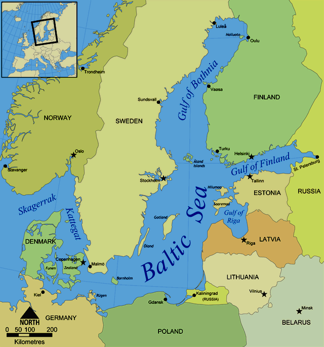
Location
map of the Baltic Sea
The Baltic Sea is a
Mediterranean sea located between Central and Northern Europe, from 53°N to 66°N latitude and from 10°E to 30°E longitude. It is bounded by the Swedish part of the Scandinavian Peninsula, the mainland of Europe, and the Danish islands. It drains into the Kattegat by way of the Øresund, the Great Belt and the Little Belt. The Kattegat continues through Skagerrak into the North Sea and the Atlantic Ocean. The Baltic Sea is connected by artificial waterways to the White Sea via the White Sea Canal, and to the German Bight of the North Sea via the Kiel Canal. The central part, also called the Baltic Proper, is bordered on its northern edge by the Gulf of Bothnia, on its northeastern edge by the Gulf of Finland, and on its eastern edge by the Gulf of Riga.
The
Baltic Sea covers about 149,000 square miles (386,000 square km). The catchment area drained by the rivers bringing fresh water into the Baltic is about four times as large as the sea itself. The Baltic proper stretches southwest-northeast on the eastern side of the Scandinavian Peninsula from latitude 54° N to very near the Arctic Circle; its major axis, from eastern Denmark to southern
Finland, is a little more than 1,000 miles (1,600 km) long, with an average width of about 120 miles (190 km). The western Baltic extends north through insular
Denmark and includes the Kattegat, a strait separating peninsular Denmark (Jutland, or Jylland) from southwestern
Sweden. The Kattegat is bounded on the north by the Skagerrak, a deep inlet of the North Sea that separates southern
Norway from northern Jutland.
The
average depth is 55 m (180 ft, 30 fathoms). The maximum depth is 459 m (1506 ft) which is on the Swedish side of the center. The surface area is about 349,644 km² (145,522 sq mi) and the volume is about 20,000 km³ (5040 cubic miles). The periphery amounts to about 8,000 km (5,000 mi) of coastline.
The
busy Baltic route leads to high levels of exhaust and other pollution.
ADMINISTRATION
The Helsinki Convention on the Protection of the Marine Environment of the Baltic Sea Area includes the Baltic Sea and the Kattegat, without calling Kattegat a part of the Baltic Sea, "For the purposes of this Convention the "Baltic Sea Area" shall be the Baltic Sea and the Entrance to the Baltic Sea, bounded by the parallel of the Skaw in the Skagerrak at 57°44.43'N."
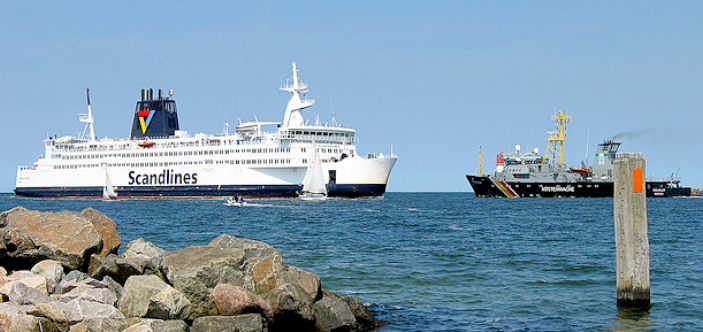
TRAFFIC
Historically, the Kingdom of Denmark collected Sound Dues from ships at the border between the ocean and the land-locked Baltic Sea. They were collected in the Øresund at Kronborg castle near Helsingør, in the Great Belt at Nyborg. In the Little Belt, the site of intake was moved to Fredericia, after that stronghold had been built. The narrowest part of Little Belt is the "Middelfart Sund" near
Middelfart.
OCEANOGRAPHY
Geographers widely agree that the preferred physical border of the Baltic is a line drawn through the southern Danish islands, Drodgen-Sill and Langeland. The Drogden Sill is situated north of Køge Bugt and connects Dragør in the south of Copenhagen to Malmö; it is used by the Øresund Bridge, including the Drogden Tunnel. By this definition, the Danish Straits are part of the entrance, but the Bay of Mecklenburg and the Bay of Kiel are parts of the Baltic Sea.
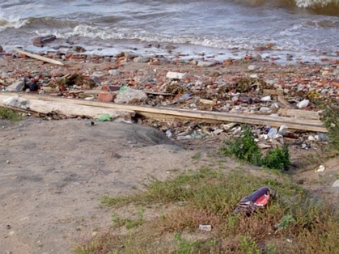
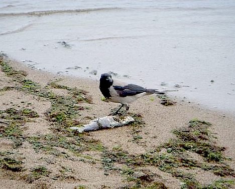
Once
plastic and other waste gets into the Baltic Sea, it cannot easily escape
into the open ocean, ending up on beaches as a subsurface soup that is
harmful to marine organisms. The Baltic Sea has a narrow outlet to the ocean - between Sweden and Denmark -
because of this the water takes 25-30 years to refresh itself. The World Wildlife Fund,
reporting on the Baltic seaport of Stralsund said low oxygen levels have rendered around 70,000 square meters of the sea uninhabitable.
The Baltic Sea is in a "critical" condition and in danger of dying unless pollution from the Russian city of St Petersburg is drastically cut.
HYDROGRAPHY and BIOLOGY
Drodgen Sill (depth of 7 metres) sets a limit to Øresund and Darss Sill (depth of 18 metres), and a limit to the Belt Sea.The shallow sills are obstacles to the flow of heavy salt water from the Kattegat into the basins around Bornholm and Gotland.
The Kattegat and the southwestern Baltic Sea are well oxygenated and have a rich biology. The remainder of the Sea is brackish, poor in
oxygen and in species. Thus, statistically, the more of the entrance that is included in its definition, the healthier the Baltic appears; conversely, the more narrowly it is defined, the more endangered its biology appears.
ECONOMY
Bulk cargoes of
oil and coal come by all water routes into the Baltic, and many exports of minerals,
timber, and wood products move in the opposite direction by sea around Jutland. These traditional exports represent a diminishing value in overall trade. The greatest values are in consumer goods, most of which are carried in containers by integrated land and sea transport to markets and to and from the North Sea ports of
Hamburg in Germany and Rotterdam in the Netherlands. This has led to increased interest in building a bridge between
Denmark and
Sweden. Shipbuilding has declined in Sweden but has continued in Poland and Finland (especially for ice-strengthened vessels); marine engines are produced in Denmark. Generally, however, light engineering, high-quality furniture production, and motor-vehicle manufacturing have replaced many of these maritime-based industries.
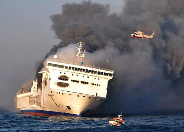
A
manned ferry carrying around 240 souls caught fire on the Baltic Sea, injuring 22 people. An explosion on the upper deck of the Lisco Gloria set the ship ablaze. It was not immediately clear what caused the explosion according to reports. The Lithuanian-flagged ferry was travelling from the German port of Kiel to
Klaipeda, Lithuania. Six other ships rushed to the scene to help evacuate passengers and crew shortly after the accident.
Three people were taken to hospitals by helicopter and the others were being taken back to Germany on another ferry.
Unmanned ships not only are better equipped with fire sensors, but also
react to emergencies quicker than a human
crew.
ENVIRONMENTAL
ISSUES
Since
World War II, various nations, including the Soviet Union, the United Kingdom and the United States, have disposed of chemical weapons in the Baltic Sea, raising concerns of environmental contamination. Even now fishermen accidentally retrieve some of these materials: the most recent available report from the Helsinki Commission notes that four small scale catches of CW
munitions representing approximately 105 kilograms (231 lbs) of material were reported in 2005. This is a reduction from the 25 incidents representing 1,110 kilograms (2,447 lbs) of material in 2003. Until now, the U.S. government refuses to disclose the exact coordinates of the wreck sites. Rotting bottles leak Lost and other substances, thus slowly poisoning a substantial part of the Baltic Sea.
Slimy and disgusting algae have become a daily problem for holidaymakers along the Baltic shores. Industrial emissions and untreated municipal sewage water have over the last century left the sea suffocated. This is common knowledge and efforts are being made to cope with the problem. However, something quite appalling is about to happen, something that is not as widely known.
Giant animal farms are emerging around the Baltic Sea. The EU has decided to make
agriculture more efficient in
Poland. Russia is to become a self-sufficient meat producer. Multinational food companies are establishing themselves around the Baltic. A large
pig farm pollutes as much a small town. But, in contrast to a municipality, there is no or insufficient sewage treatment. And there are thousands of farms being established in the region. The hunger for
meat is turning the Baltic into a giant
cesspool of animal
excrement. Agricultural and environmental policies are on a collision
course, it's industry versus the environment.
In this film, the beautiful landscapes of Europe and
Russia stand in stark contrast to scientific warnings, to people who are affected and the corporations feathering their nests. For the first time, the people around the Baltic Sea will get this complex situation explained, learn about possible solutions and actions and hear from the politicians responsible.
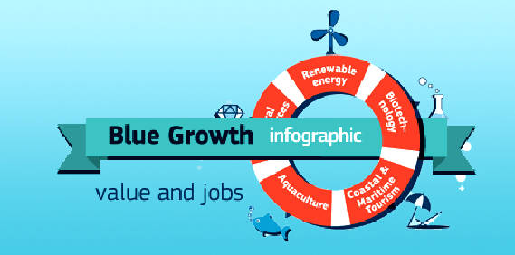
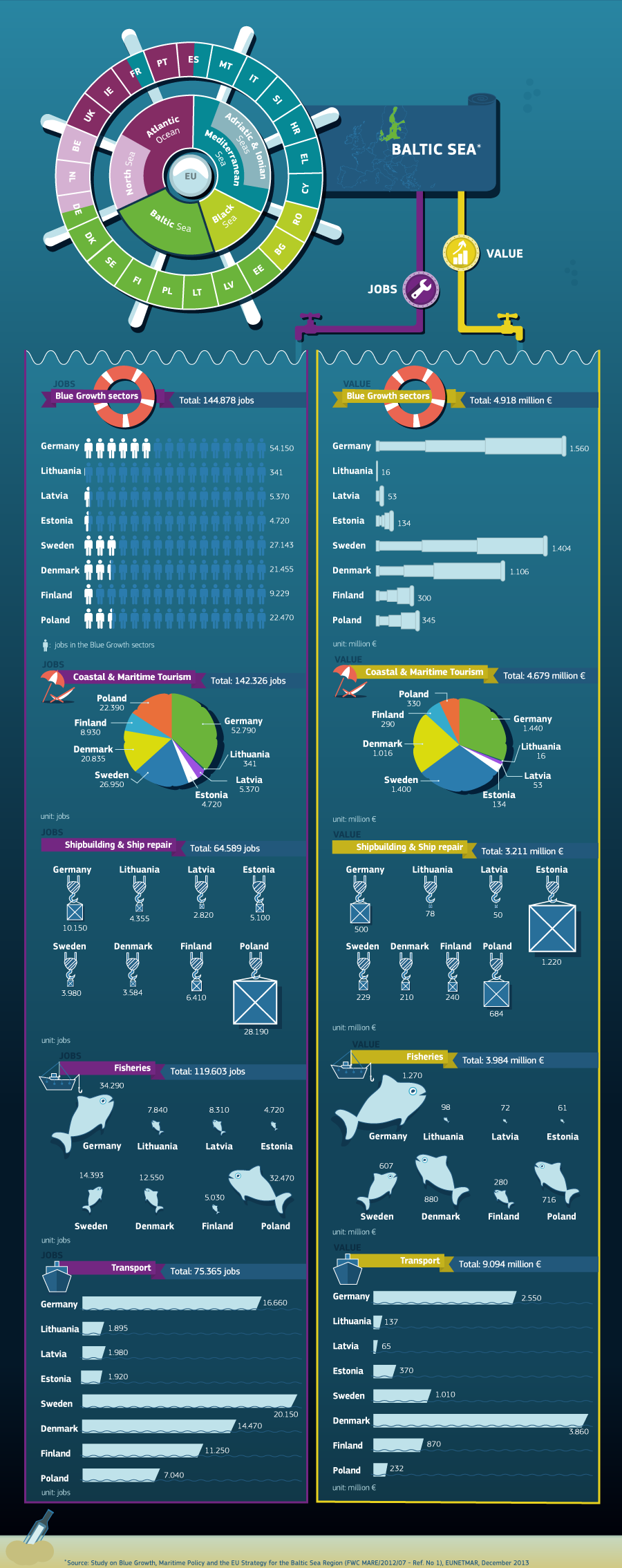
BLUE
GROWTH - Delivering a Sustainable Blue Growth Agenda for the Baltic Sea Region
26/05/2014
The Baltic Sea agenda for sustainable blue growth, adopted by the European Commission on 16 May 2014, provides a blueprint for harnessing the region’s strengths to boost innovation and growth in the maritime area. Sustainability is an integral part of the plan as it can act as a driver for innovation and more jobs, like in the area of
clean
shipping.
The Baltic Sea region's specific characteristics provide it with the opportunity to combine responses to environmental challenges with extraordinary assets, such as competitive and innovative research and business sectors and a strong tradition of cooperation.
The EU document proposes:
*
Consistent approach to innovations, increased sustainability.
* Innovation streams should cut across the areas, such as maritime technologies, biotechnologies, renewable energy, port reception facilities, maritime and coastal tourism including cruise industry, and
aquaculture.
* Focus on the right skills and qualifications, cluster development.
* Better targeted funding to support maritime projects.
* This has to be implemented through multi-sectoral stakeholder dialogue, building on existing work, in full coordination with the EU Strategy for the Baltic Sea region and making full use of available funding.
Growth and a healthy marine environment should go hand in hand. Sustainability is an integral part of the regional Blue growth agenda. Moreover, it should be seen as a driver of innovation and more growth and jobs.
Clean shipping is one example of this.
The Commission is ready to facilitate the implementation of the Sustainable Blue Growth Agenda in the Baltic Sea Region through a dedicated multi-sectoral maritime stakeholder platform. In the course of 2014-2015, the Commission in cooperation with stakeholders will organise a series of workshops dedicated to Blue Growth and funding opportunities in the Baltic Sea region.
A Sustainable Blue Growth Agenda for the Baltic Sea Region (Commission staff working document adopted on 16 May 2014).
Background:
The Blue growth study concluded last year (more information available on Maritime Forum) reconfirmed that there is a huge potential for the development of maritime economy in the Baltic Sea region. Recent growth rates are above the growth average in the EU: offshore wind has increased in the region by 20%, cruise tourism by 11% and marine aquaculture by 13%. Short-sea shipping, coastal and cruise tourism, offshore wind, shipbuilding, aquaculture and blue biotechnologies are among the most promising sectors of the Baltic Sea maritime economy.
The EU Strategy for the Baltic Sea region (EUSBSR) has been the EU framework for regional action in the Baltic Sea area for the past five years and its recently revised Action Plan has an important maritime component.
Some examples of successfully completed maritime projects include establishment of the Baltfish forum that is a pioneer in regional fisheries management, integration between maritime authorities across sectors and across borders through the successfully completed MARSUNO project, projects related to Clean Shipping, e-navigation and LNG, BONUS calls for clean tech and eco-innovations.
The Action plan of the EUSBSR contains further actions related to the blue economy, such as the "Submariner network" addressing sustainable innovative uses of marine resources (focus on aquaculture, blue
biotech and wave energy), maritime related innovations ranging from maritime industries to renewable energy, enhanced cooperation in research and fisheries management, clean shipping and building competences on LNG, networking and clustering of maritime
tourism stakeholders and preservation of maritime heritage, etc. All this is underpinned by a common approach for cross-border cooperation on MSP.
The focus on Blue growth could be further improved through strengthening the EUSBSR action plan in a number of areas. This could include new flagships related to
offshore
energy, aquaculture, blue
biotechnology, maritime technologies, skills and cluster development.
THE
BALTIC SEA MEDIA PROJECT (BSMP)
The Baltic Sea is one of the most studied seas in the world. The environmental problems are well known.
The main threats derive from eutrophication, hazardous substances, over-fishing and maritime transport. The Baltic Sea is surrounded by some of the world's most environmentally conscious societies. And scientists all agree on the most important steps to take. Still, in many respects, the state of this sensitive and almost landlocked sea is deteriorating.
The efforts to save the sea are spoiled by national disagreements and short-term interest.
The future and life quality of 90 million people are affected by the Baltic Sea environment. The next ten years will be critical. Can we save the sea that ties us together?
Filmmakers Mattias Klum and Folke Rydén are spending ten years documenting the efforts to save the Baltic Sea. Focusing on the decision-making processes for environmental, scientific and political issues, the aim is to produce a
television documentary every other year in cooperation with public service broadcasters around the region. The first programme will be completed in the autumn of 2009.
At the same time, production of an international feature documentary will begin (for release in 2017) as well as creation of a range of interactive educational material for use in the whole Baltic region.

CONTACT
BSMP
Baltic Sea 2020
www.balticsea2020.org
E-mails: info@balticsea2020.org
mail@ourbalticsea.com
Folke Rydén Production AB
www.folkeryden.com
E-mail:
info@frp.se
Mattias Klum Tierra Grande AB
www.mattiasklum.com
E-mail: info@mattiasklum.se


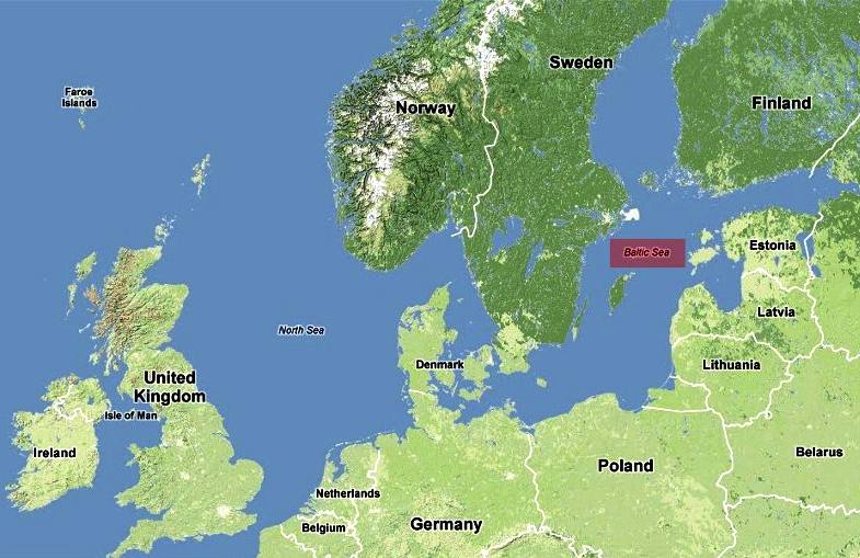
A
map of Northern Europe including the North and Baltic Seas
FROZEN
SEAS
The Baltic Sea is ice-covered at the annual maximum for about 45% of its surface
area on average. The ice-covered area during such a typical winter includes the Gulf of Bothnia, the Gulf of Finland, Gulf of Riga, Väinameri in the Estonian archipelago, the Stockholm archipelago and the Archipelago Sea of Finnish territorial waters. The remainder of the Baltic itself does not freeze during a normal winter, with the exception of sheltered bays and shallow lagoons such as the Curonian Lagoon. The ice reaches its maximum extent in February or March; typical ice thickness in the northernmost areas in the Bothnian Bay, the northern basin of the Gulf of Bothnia, is about 70 cm (28 in) for landfast sea ice. The thickness decreases farther south.
Freezing begins in the northern extremities of Gulf of Bothnia typically in the middle of November, reaching the open waters of the Bothnian Bay in early January. The Bothnian Sea, the basin south of Kvarken, freezes on average in late February. The Gulf of Finland and the Gulf of Riga freeze typically in late January. In 2011, the Gulf of Finland was completely frozen on 15 February.
The ice extent depends on whether the winter is mild, moderate or severe. Severe winters can lead to ice formation around southern Sweden and even in the Danish straits. According to the 18th-century natural historian William Derham, during the severe winters of 1703 and 1708, the ice cover reached as far as the Danish straits. Frequently, parts of the Gulf of Bothnia and Gulf of
Finland are frozen, in addition to coastal fringes in more southerly locations such as the Gulf of Riga. This description meant that the whole of the Baltic Sea was covered with ice.
It is known that since 1720, the Baltic Sea has frozen over entirely only 20 times. The most recent case was in early 1987, which was the most severe winter in Scandinavia since that date. The ice then covered 400,000 km2 (150,000 sq mi). During the winter of 2010–11, which was quite severe compared to those of the last decades, the maximum ice cover was 315,000 km2, which was reached on 25 February 2011. The ice then extended from the north down to the northern tip of Gotland, with small ice-free areas on either side, and the east coast of the Baltic Sea was covered by an ice sheet ca. 25–100 km (16–62 mi) wide all the way to Gdańsk. This was brought about by a stagnant high-pressure area that lingered over central and northern Scandinavia from ca. 10 to 24 February. After this, strong southern winds pushed the ice further into the north, and much of the waters north of Gotland were again free of ice, which had then packed against the shores of southern Finland. The effects of the afore-mentioned high-pressure area did not reach the southern parts of the Baltic Sea, and thus the entire sea did not freeze over. However, floating ice was additionally observed near Świnoujście harbour in January 2010.
In the recent years prior to 2011, the Bothnian Bay and the Bothnian Sea were frozen with solid ice near the Baltic coast and dense floating ice far from it. In 2008, there was almost no ice formation except for a short period in March.
Piles of drift ice on the shore of Puhtulaid, near Virtsu, Estonia, in late April
During winter, fast ice, which is attached to the shoreline, develops first, rendering the ports unusable without the services of icebreakers. Level ice, ice sludge, pancake ice, and rafter ice form in the more open regions. The gleaming expanse of
ice is similar to the
Arctic, with wind-driven pack ice and ridges up to 15 m (49 ft). Offshore of the landfast ice, the ice remains very dynamic all year, and it is relatively easily moved around by winds and therefore forms pack ice, made up of large piles and ridges pushed against the landfast ice and shores.
In spring, the Gulf of Finland and the Gulf of Bothnia normally thaw in late April, with some ice ridges persisting until May in the eastern extremities of the Gulf of Finland. In the northernmost reaches of the Bothnian Bay, ice usually stays until late May; by early June it is practically always gone.
The ice cover is the main habitat for two large mammals, the grey seal (Halichoerus grypus) and the Baltic ringed seal (Pusa hispida botnica), both of which feed underneath the ice and breed on its surface. Of these two seals, only the Baltic ringed seal suffers when there is not adequate ice in the Baltic Sea, as it feeds its young only on ice. The grey seal is adapted to reproducing also with no ice in the sea. The sea ice also harbours several species of algae that live in the bottom and inside unfrozen brine pockets in the ice.
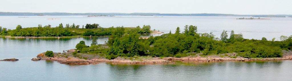
Aland
Island, Baltic Sea - is an area with significant environmental issues.
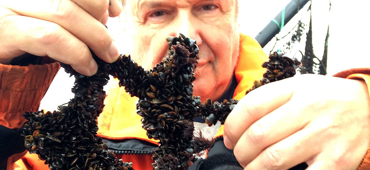
MUSSEL GROWING IN THE BALTIC
- Cultivating and harvesting blue mussels in the Baltic Sea can substantially improve the water quality as mussels take up nutrients through their food intake. At the same time, it can contribute to blue growth by providing new business models for the feed industry, which can use mussel meal as an ingredient in animal feed, replacing e.g. imported fish and soybean meal.
Mussel farming in the Baltic Sea has so far not gone beyond experimental scale.
To build up a commercially viable mussel farming value chain, it is not only necessary to develop suitable farming techniques for Baltic Sea conditions, but also to develop accepted mechanisms to compensate the ecosystem services provided by mussel farming.
HISTORY
In the early Middle Ages, Norse (Scandinavian) merchants built a trade empire all around the Baltic. Later, the Norse fought for control of the Baltic against Wendish tribes dwelling on the southern shore. The Norse also used the rivers of
Russia for trade routes, finding their way eventually to the Black Sea and southern Russia. This Norse-dominated period is referred to as the Viking Age.
Since the Viking age, the Scandinavians have referred to the Baltic Sea as Austmarr ("Eastern Lake"). "Eastern Sea", appears in the Heimskringla and Eystra salt appears in Sörla þáttr. Saxo Grammaticus recorded in Gesta Danorum an older name, Gandvik, "-vik" being Old Norse for "bay", which implies that the Vikings correctly regarded it as an inlet of the sea. Another form of the name, "Grandvik", attested in at least one English translation of Gesta Danorum, is likely to be a misspelling.)
In addition to fish the sea also provides amber, especially from its southern shores. The bordering countries have traditionally exported lumber, wood tar, flax, hemp and furs by ship across the Baltic. Sweden had from early medieval times exported iron and
silver mined there, while
Poland had and still has extensive salt mines. Thus the Baltic Sea has long been crossed by much merchant shipping.
The lands on the Baltic's eastern shore were among the last in Europe to be converted to Christianity. This finally happened during the Northern Crusades: Finland in the twelfth century by Swedes, and what are now Estonia and Latvia in the early thirteenth century by Danes and
Germans (Livonian Brothers of the Sword). The Teutonic Order gained control over parts of the southern and eastern shore of the Baltic Sea, where they set up their monastic state. Lithuania was the last European state to convert to Christianity.
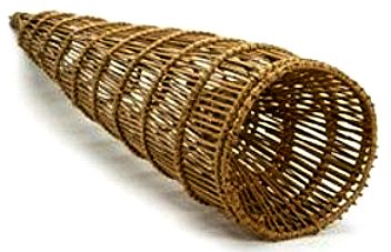
World's
oldest - 9,000 year old stationary fishing trap is similar to baskets in
use by cultures all over the world today.
ARCHAEOLOGY
- JUNE 2012
Swedish marine archaeologists have found what they believe are the world’s oldest stationary fishing traps on the bottom of the Baltic Sea; the oldest dates back at least 9,000 years.
Archaeologist Arne Sjostrom, of Sodertorn University, Stockholm, found the remains of 7 basket traps, constructed from hazel rods and bound together, in an ancient river valley off Sweden’s southern coast, now submerged at a depth of 5-12 meters.
Carbon dating of one of the baskets estimates it to be around 9,000 years old and Sjostrom is “pretty confident this is the world’s oldest
stationary fishing trap that has been found so far.”
This find mirrors the discovery of similar fishing traps in the North Sea at submerged sites in what was Doggerland. It has been estimated that the human inhabitants of Doggerland during the Mesolithic acquired 60% of their protein from sea foods (including salmon, flounder, cod, & oysters). So abundant were these marine resources, that they left their nomadic game hunting lifestyle and settled down into sedentary communities. The super-successful fish trap developed during the Mesolithic, is essentially identical in design to those still used in parts of the world to this day.
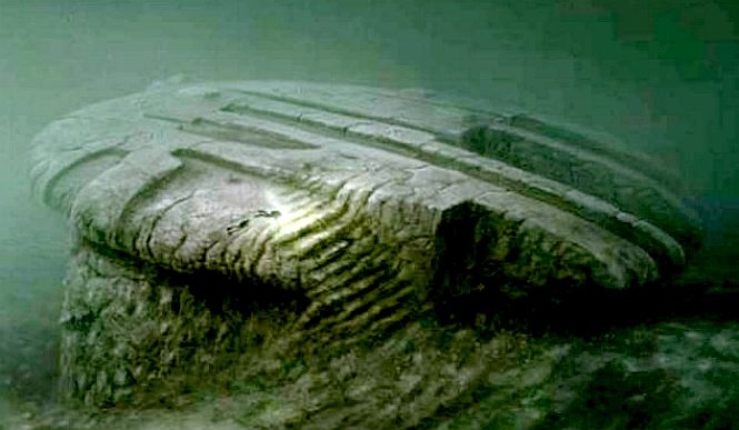
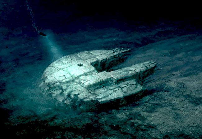
Artists
impressions of the 'Baltic Anomaly.' The discovery was made on June 19, 2011 by the Swedish based “Ocean X Team” during a dive in the Baltic Sea between Sweden and Finland while searching for an old shipwreck. The group describes themselves as
treasure hunters and salvage operators who specialize in underwater searches for sunken “antique high-end alcoholic beverages and historic
artifacts”. In March 2012, Ocean X formalized a partnership with entertainment producers Titan TV to produce a TV documentary series and documentary film.
JUNE
2011 - OCEAN
X - BALTIC SEA ANOMALY
The Baltic Sea anomaly is a 60-metre (200 ft) circular rock-like formation on the floor of the Baltic Sea, discovered by Peter Lindberg, Dennis Åsberg and their Swedish “Ocean X” diving team in June 2011. The team reported that the formation rests on a pillar and includes a structure similar in appearance to a staircase, leading to a dark hole.
Commentators have suggested that the structure could be a World War II
anti-submarine device, a battleship gun turret, sediment dropped by a fishing trawler, or a flying saucer. Several experts have stated that it is most likely a natural geological formation.
According to Ocean X, the formation has an appearance of “rough granite”, is round, 3 to 4 metres (9.8 to 13.1 ft) thick and approximately 60 metres (200 ft) in diameter, stands on an 8-meter (26 ft) tall pillar-like feature, and is located at a depth of 85 to 90 metres (279 to 295 ft). There is also another smaller object not far away. The object is at the end of what resembles a 300-metre (980 ft) “runway”.
The Ocean X team has published one additional close-up sonar scan on their Web site and nine additional close-up sonar scans on their YouTube page that appear to show a 90-degree angle and other features of the object.
On their second expedition, they reported that they found something that looks like a staircase and a round black hole that goes directly into the structure.
Dennis Asberg, September 28, 2012: “It is not an object which is man made in modern time. What ever it is it’s either from during the ice age or pre-ice age.” – Peter Lindberg, February 24, 2013 “The object is older than 140.000 yrs. Older than that… with straight angles/lines – rounded corners… much like a “dinner plate” and separate from the base below.”
There are THREE objects of interest – 1) the main 60 meter circular anomaly, 2) a smaller secondary object lying approx. 200 meters from the 1st anomaly with an area shaped like two “Gothic church windows” and 3) a third anomaly – a 28 meters high and 275 meters wide rock outcrop with a crack running through it, lying some 1500 metres South of the circular object, direct on the other end of the “trail”. The team has stated Anomaly 2 might turn out to be the most interesting than the first, and they plan to dive on it this time around
There are two holes on the anomaly. One is 25 centimeters in diameter, and the other is 2 meters surrounded by a square formation. It’s not yet known where the holes lead.
“What I do not believe because I know, is the fact that we found a round hole approx 25 cm in diameter going straight into the surface of the circle, how odd is not that? How deep? No idea, we just saw it for some seconds before we decided to back off to preserve the visibility for the divers that was going down later on."
It looks like there are stair-like structures on the top right side (North-East) as well as the lower bottom left (South-West) of the 60 meter circular object. (Peter confirmed the “staircase” reference was only an example to describe what he saw and that steps on the lower south-west side are comprised of 8 steps with each step a 1 meter drop starting from the missing section on the left.)
“The staircase comment was slipped from my mouth, and probably too early. I have seen something that looks like a stair, or steps, on the Multi Beam raw data. And it looks like they are going from the missing part on the left side of the side scan image from last year and down to the bottom. I could only count eight of them and that should mean that every step should be like a meter high which is a bit to high for a person to use. If there actually are something that looks like steps they probably just natural.”
Peter
Lindberg – June 28, 2012: “Someone asked about the stairs, there is stair shaped formations but I do not know if I have got it right. I thought they were on one side but on the Multi beam image they appeared to be on an other side. I will come back to the stairs when I can study an image from a different angle."
REGIONAL
BRANDING 2013 - STOCKHOLM
In
2013 the Nordic Place Branding Conference 2013 was held in Stockholm. Representatives from cities, regions and government agencies in the five Nordic countries met to listen to speakers discussing their various place branding efforts.
Several of the speakers talked about the challenge to get stakeholders, such as citizens of the location and business, to support branding efforts. Another issue that came up was what was place branding is all about: is mostly it a matter of marketing yourself by creating clever campaigns and taglines or of developing your place and its people and live by your values? Words or deeds? Or both?
The need to put the Baltic Sea Region on the map, both in terms of creating a ‘we-feeling’ in the region and making the region known globally, has been a much-discussed issue for some time.
For the Baltic Sea Region, building a brand is obviously about smart communication: telling people in the region and outside world that we exist, and that we do a lot of good things here, in each country and together, in collaboration. Come and visit, invest, start a business, live, work or study here should be the messages.
But it is also about working together and solving real, concrete problems and unlocking opportunities in order to build a better, cleaner, more prosperous and attractive region – through common strategies, projects and activities.
BALTIC
SEA TOURISM COMMISSION (BTC)
Baltic Sea Tourism Commission
c/o FIN-S Marknad & Kommunikation
Snickarbacken 2, 4-5 tr
S-111 39 Stockholm
Mobile +46 70 731 85 68
Telephone +46 8 667 25 97
Fax: +46 8 667 64 29
E-mail: info@balticsea.com
ACIDIFICATION
- ADRIATIC
- ARCTIC
- ATLANTIC - BALTIC
- BAY BENGAL - BERING
- BLACK - CARIBBEAN - CORAL - EAST
CHINA
ENGLISH CH
-
GOC - GULF
GUINEA - GULF
MEXICO
- HORMUZ - INDIAN
-
IOC
-
IRC - MEDITERRANEAN -
NORTH SEA - PACIFIC
- PERSIAN GULF
RED
SEA - SEA
JAPAN - STH
CHINA - PLASTIC
- PLANKTON - PLASTIC
OCEANS - SEA
LEVEL RISE - TAIWAN - UNCLOS
- UNEP
WOC
- WWF
AMAZON
- BURIGANGA - CITARUM - CONGO - CUYAHOGA
-
GANGES - IRTYSH
- JORDAN - LENA -
MANTANZA-RIACHUELO
MARILAO
- MEKONG - MISSISSIPPI - NIGER -
NILE - PARANA - PASIG - SARNO - THAMES
- YANGTZE - YAMUNA - YELLOW
LINKS
& REFERENCE
Abroad
In The Yard 9000-year-old-fishing-traps-found-on-bottom-of-baltic-sea Baltic
Sea 2020
Wikipedia
Baltic_Sea
Britannica
Baltic-Sea Baltic
Sea Save
Our Baltic Sea Youtube
Watch IOL
Ferry-explodes-on-the-baltic-sea News
Wave branding-baltic-sea-region-style Helcom
The
Baltic Anomaly
Vilnius
Macerata Adriatic and Baltic seas pollution https://ec.europa.eu/maritimeaffairs/policy/biotechnology_en https://ec.europa.eu/maritimeaffairs/content/delivering-sustainable-blue-growth-agenda-baltic-sea-region_en https://www.submariner-network.eu/projects/balticbluegrowth/about-baltic-blue-growth http://vilnius-macerata.wikispaces.com/Adriatic+and+Baltic+seas+pollution
http://www.abroadintheyard.com/9000-year-old-fishing-traps-found-on-bottom-of-baltic-sea/
http://www.balticsea2020.org
http://en.wikipedia.org/wiki/Baltic_Sea
http://www.britannica.com/EBchecked/topic/50963/Baltic-Sea
http://balticsea.com/ http://www.saveourbalticsea.com/ http://www.youtube.com/watch?v=20y2NvIEB7E#t=139 http://www.iol.co.za/news/world/ferry-explodes-on-the-baltic-sea-1.685008#.VCx651cXOSo
http://newswave.eu/place-branding-baltic-sea-region-style/
http://thebalticanomaly.se/
http://helcom.fi/
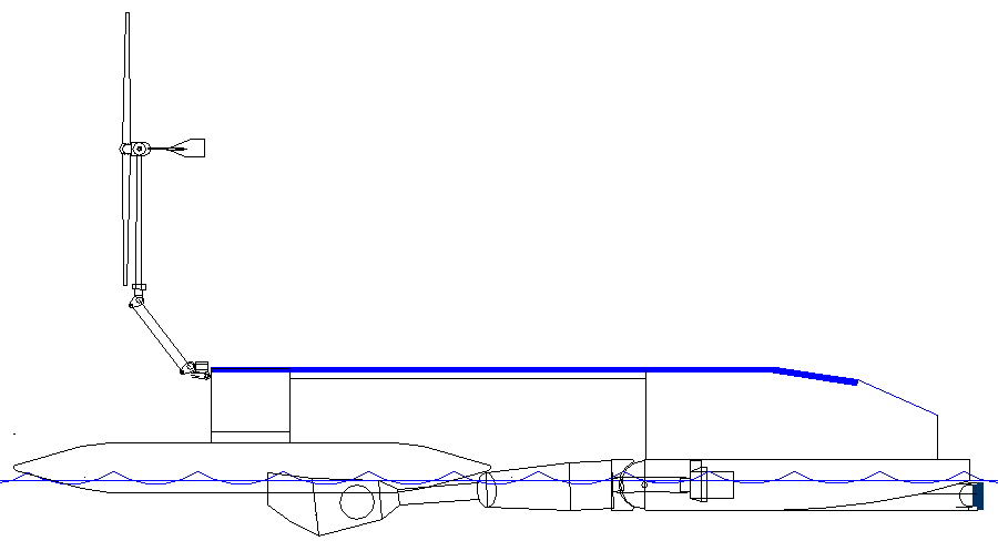
CLEAN
UP YOUR OCEAN - Based on the Bluefish ZCC concept, that above
feasibility design is a proposed trimaran test rig, using off-the-shelf
components to get a feel for the concept. This is in no way a complete
solution, but then we have to start somewhere. What we learn from these
small scale experiments, could eventually help us to formulate a dual
purpose, ocean capable cruiser, to clean up the Baltic Sea and local
harbours, with a view to cleansing the marine environment and improving
the quality of beaches and locally caught fish, etc. Full size, this
autonomous vessel could harvest up to 50 tons of plastic,
before it has to offload. There is an existing market for recycled
plastic. That's good, because building the world's largest robot
vacuum cleaner is not going to be easy. We need all the support
we can get.
|