|
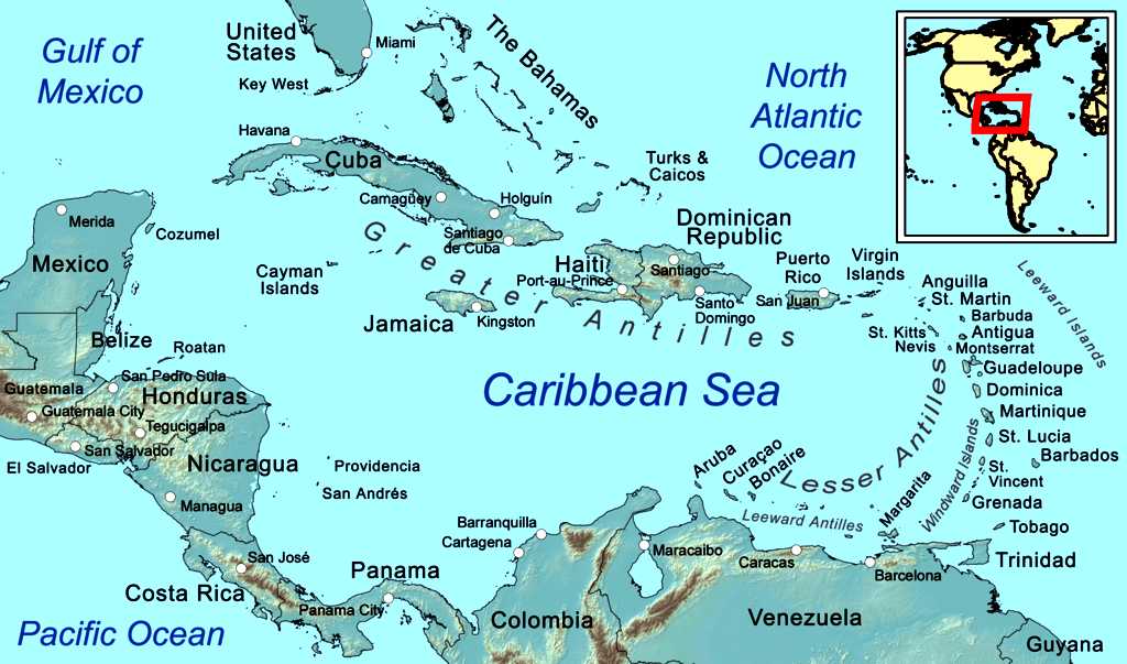
Map
of the Caribbean Sea, with inset showing world location. The Caribbean Sea region is located southeast of the Gulf of Mexico and the North American mainland, east of Central America, north of South America and West of the Atlantic Ocean.
The Caribbean Sea is a sea of the Atlantic Ocean located in the tropics of the Western hemisphere. It is bounded by the Yucatán Peninsula of
Mexico and Central America to the west and southwest, to the north by the Greater Antilles starting with Cuba, to the east by the Lesser Antilles, and to the south by the north coast of South America.
The entire area of the Caribbean Sea, the numerous islands of the West Indies, and adjacent coasts, are collectively known as the Caribbean. The Caribbean Sea is one of the largest seas and has an area of about 2,754,000 km² (1,063,000 sq. mi.). The sea's deepest point is the Cayman Trough, between the Cayman Islands and Jamaica, at 7,686 m (25,220 ft) below sea level. The Caribbean coastline has many gulfs and bays: the Gulf of Gonâve, Gulf of Venezuela, Gulf of Darién, Golfo de los Mosquitos, Gulf of Paria and Gulf of Honduras.
In
2022, Caribbean islands were again engulfed in sargassum,
from the Sargasso Sea. Sargassum showed up briefly in the Caribbean in
2011 and had a massive comeback in 2015, which continued each summer
through 2021. Now it’s back in 2022, and sure to increase as climate
change continues to warm the oceans.
“In all regions combined — the tropical Atlantic, the Caribbean Sea
and the Gulf of Mexico — the total sargassum amount increased from 18.8
million tons in May 2022 to 24.2 million tons in June 2022, thus setting a
new historical record,” the University of South Florida Optical
Oceanography Lab reported.
Hard hit this year are fishermen (the stuff gets tangled in fishing lines
and engine rotors), tour boat operators, beachfront resorts, restaurants
and attractions along portions of the coastlines of Barbados, the Cayman
Islands, the Dominican Republic, Puerto Rico, St. Maarten/Martin, Jamaica
and the Mexican Caribbean.
CARIBBEAN
ISLANDS - WEST INDIES
The region, situated largely on the Caribbean Plate, has more than 700 islands, islets, reefs and cays (see the list of Caribbean islands). Three island arcs delineate the eastern and northern edges of the Caribbean Sea: The Greater Antilles to the north, and the Lesser Antilles and Leeward Antilles to the south and east. Together with the nearby Lucayan Archipelago, these island arcs make up the West Indies.
The Bahamas and the Turks and Caicos Islands are sometimes considered to be a part of the Caribbean, even though they are neither within the Caribbean Sea nor on its border. However, The Bahamas is a full member state of the Caribbean Community and the Turks and Caicos Islands are an associate member. Belize, Guyana, and Suriname are also considered part of the Caribbean despite being mainland countries and they are full member states of the Caribbean Community and the Association of Caribbean States. Several regions of mainland North and South America are also often seen as part of the Caribbean because of their political and cultural ties with the region. These include Belize, the Caribbean region of Colombia, the Venezuelan Caribbean, Quintana Roo in Mexico (consisting of Cozumel and the Caribbean coast of the Yucatán Peninsula), and The Guianas (Guyana, Suriname, French Guiana, Guayana Region in Venezuela, and Amapá in Brazil).
The islands of the Caribbean (the West Indies) are often regarded as a subregion of North America, though sometimes they are included in Middle America or then left as a subregion of their own and are organized into 30 territories including sovereign states, overseas departments, and dependencies. From 15 December 1954, to 10 October 2010, there was a country known as the Netherlands Antilles composed of five states, all of which were Dutch dependencies. From 3 January 1958, to 31 May 1962, there was also a political union called the West Indies Federation composed of ten English-speaking Caribbean territories, all of which were then British dependencies.
These islands include active volcanoes, low-lying atolls, raised limestone islands, and large fragments of continental crust containing tall mountains and insular rivers. Each of the three archipelagos of the West Indies has a unique origin and geologic composition.
GREATER ANTILLES
The Greater Antilles is geologically the oldest of the three archipelagos and includes both the largest islands (Cuba,
Jamaica, Hispaniola, and Puerto Rico) and the tallest mountains (Pico Duarte, Blue Mountain, Pic la Selle, Pico Turquino) in the Caribbean. The islands of the Greater Antilles are composed of strata of different geological ages including Precambrian fragmented remains of the North American Plate (older than 541 million years), Jurassic aged limestone (201.3-145 million years ago), as well as island arc deposits and oceanic crust from the Cretaceous (145-66 million years ago).
The Greater Antilles originated near the Isthmian region of present day Central America in the Late Cretaceous (commonly referred to as the Proto-Antilles), then drifted eastward arriving in their current location when colliding with the Bahama Platform of the North American Plate ca. 56 million years ago in the late Paleocene. This collision caused subduction and volcanism in the Proto-Antillean area and likely resulted in continental uplift of the Bahama Platform and changes in sea level. The Greater Antilles have continuously been exposed since the start of the Paleocene or at least since the Middle Eocene (66-40 million years ago), but which areas were above sea level throughout the history of the islands remains unresolved.
The oldest rocks in the Greater Antilles are located in Cuba. They consist of metamorphosed graywacke, argillite, tuff, mafic igneous extrusive flows, and carbonate rock. It is estimated that nearly 70% of Cuba consists of karst limestone. The Blue Mountains of Jamaica are a granite outcrop rising over 2,000 meters, while the rest of the island to the west consists mainly of karst limestone. Much of Hispaniola, Puerto Rico, and the Virgin Islands were formed by the collision of the Caribbean Plate with the North American Plate and consist of 12 island arch terranes. These terranes consist of oceanic crust, volcanic and plutonic rock.
LESSER ANTILLES
The Lesser Antilles is a volcanic island arc rising along the leading edge of the Caribbean Plate due to the subduction of the Atlantic seafloor of the North American and South American plates. Major islands of the Lesser Antilles likely emerged less than 20 Ma, during the Miocene. The volcanic activity that formed these islands began in the Paleogene, after a period of volcanism in the Greater Antilles ended, and continues today. The main arc of the Lesser Antilles runs north from the coast of Venezuela to the Anegada Passage, a strait separating them from the Greater Antilles, and includes 19 active volcanoes.
LUCAYAN ARCHIPELAGO
The Lucayan Archipelago includes The Bahamas and the Turks and Caicos Islands, a chain of barrier reefs and low islands atop the Bahama Platform. The Bahama Platform is a carbonate block formed of marine sediments and fixed to the North American Plate. The emergent islands of the Bahamas and Turks and Caicos likely formed from accumulated deposits of wind-blown sediments during Pleistocene glacial periods of lower sea level.
ECOLOGY
The Caribbean is home to about 9% of the world's
coral reefs covering about 20,000 square miles (52,000 km2), most of which are located off the Caribbean Islands and the Central American coast. Among them stands out the Belize Barrier Reef with an area of 96,300 ha which was declared a World Heritage Site in 1996. It forms part of the Great Mayan Reef also known as the MBRS and being over a thousand km in length is the world's second longest. It runs along the Caribbean coasts of Mexico, Belize, Guatemala and Honduras.
During the past ten years, unusually warm Caribbean waters have been increasingly threatening Caribbean coral reefs. Coral reefs support some of the most diverse marine habitats in the world, but they are fragile ecosystems. When tropical waters become unusually warm for extended periods of time, microscopic plants called zooxanthellae, which are symbiotic partners living within the coral polyp tissues, die off. These plants provide food for the corals, and give them their color. The result of the death and dispersal of these tiny plants is called coral bleaching, and can lead to the devastation of large areas of reef. Over 42% of corals are completely bleached and 95% are experiencing some type of whitening.
The habitats supported by the reefs are critical to such tourist activities as fishing and diving, and provide an annual economic value to Caribbean nations of $3.1-$4.6 billion. Continued destruction of the reefs could severely damage the region's economy. A Protocol of the Convention for the Protection and Development of the Marine Environment of the Wider Caribbean Region came in effect in 1986 to protect the various endangered marine life of the Caribbean through forbidding human activities that would advance the continued destruction of such marine life in various areas. Currently this protocol has been ratified by 15
countries. Also several charitable organisations have been formed to preserve the Caribbean marine life, such as Caribbean Conservation Corporation which seeks to study and protect sea turtles while educating others about them.
In connection with the foregoing, the Institute of Marine Sciences and Limnology of the National Autonomous University of Mexico, conducted a regional study, funded by the Department of Technical Cooperation of the International Atomic Energy Agency, in which specialists from 11 Latin American countries (Colombia, Costa Rica, Cuba, Guatemala, Haiti, Honduras, Mexico, Nicaragua, Panama, Dominican Republic, Venezuela plus Jamaica) participated. The findings indicate that heavy metals such as mercury, arsenic and lead, have been identified in the coastal zone of the Caribbean Sea. Analysis of toxic metals and hydrocarbons is based on the investigation of coastal sediments that have accumulated less than 50 meters deep during the last hundred and fifty years. The project results were presented in Vienna in the forum "Water Matters", and the 2011 General Conference of said multilateral organization.
OCEANOGRAPHY
The hydrology of the sea has a high level of homogeneity. Annual variations in monthly average water temperatures at the surface do not exceed 3°C (25°-28°C). Over the past fifty years the Caribbean has gone through three stages: cooling until 1974; a cold phase with peaks during 1974-1976 and 1984-1986 then; a warming phase with increase in temperature of 0.6°C per year. Virtually all temperature extremes were associated with the phenomena of el Niño and la Niña. The salinity of sea water is about 3.6% and its density is 1.0235-1.0240 kg². The surface water colour is blue-green to green.
GEOLOGY
The Caribbean Sea is an oceanic sea largely situated on the Caribbean Plate. The Caribbean Sea is separated from the ocean by several island arcs of various ages. The youngest of them stretches from the Lesser Antilles to the Virgin Islands to the north east of Trinidad and Tobago off the coast of Venezuela. This arc was formed by the collision of the South American Plate with the Caribbean Plate and includes active and extinct volcanoes such as Mount Pelee, the Quill (volcano) on Sint Eustatius in the Caribbean Netherlands and Morne Trois Pitons on Dominica. The larger islands in the northern part of the sea Cuba, Haiti, Jamaica and Puerto Rico lie on an older island arc. The geological age of the Caribbean Sea is not known with certainty but is estimated to have an age between 160 and 180 million years and was formed by a horizontal fracture that split the supercontinent called Pangea in the Mesozoic Era. It is assumed that the proto-caribbean basin existed in the Devonian period. In the early Carboniferous movement of Gondwana to the north and its convergence with the Euramerica basin decreased in size. The next stage of the formation of the Caribbean Sea began in the Triassic.
Powerful rifting led to the formation of narrow troughs, stretching from modern Newfoundland to the west coast of the Gulf of Mexico which formed siliciclastic sedimentary rocks. In the early Jurassic due to powerful marine transgression, water broke into the present area of the Gulf of Mexico creating a vast shallow pool here. The emergence of deep basins in the Caribbean occurred during the era of the Middle Jurassic rifting. The emergence of these basins marked the beginning of the Atlantic Ocean and contributed to the destruction of Pangaea at the end of the late Jurassic. During the Cretaceous the Caribbean acquired the shape close to that seen today. In the early Paleogene due to Marine regression the Caribbean became separated from the Gulf of Mexico and the Atlantic Ocean by the land of Cuba and Haiti. The Caribbean remained like this for most of the Cenozoic until the Holocene when rising water levels of the oceans restored communication with the Atlantic Ocean.
The floor of the Caribbean is composed of sub-oceanic sediments of deep red clay in the deep basins and troughs. On continental slopes and ridges calcareous silts are found. Clay minerals likely having been deposited by the mainland river Orinoco and the Magdalena River. Deposits on the bottom of the Caribbean Sea and Gulf of Mexico have a thickness of about 1 km. Upper sedimentary layers relate to the period from the Mesozoic to the Cenozoic (250 million years ago to present) and the lower layers from the Paleozoic to the Mesozoic.
The Caribbean sea floor is divided into five basins separated from each other by underwater ridges and mountain ranges. Atlantic Ocean water enters the Caribbean through the Anegada Passage lying between the Lesser Antilles and Virgin Islands and the Windward Passage located between Cuba and Haiti. The Yucatan Channel between Mexico and Cuba links the Gulf of Mexico with the Caribbean. The deepest points of the sea lie in Cayman Trough with depths reaching approximately 7,686 m (25,220 ft). Despite this, the Caribbean Sea is considered a relatively shallow sea in comparison to other bodies of water.
THE
CARIBBEAN ISLANDS BY POPULATION
1
Cuba
11,252,999
2 Haiti
11,263,077 (Hispaniola)
3 Dominican
Republic 10,766,998 (Hispaniola)
4 Puerto
Rico (US) 3,508,000
5 Jamaica
2,729,000
6 Trinidad
and Tobago 1,357,000
7 Guadeloupe
(France) 405,000
8 Martinique
(France) 383,000
9 Bahamas
379,000
10 Barbados
283,000
11 Saint
Lucia 172,000
12 Curaçao
(Netherlands) 157,000
13 Aruba
(Netherlands) 110,000
14 Saint
Vincent and the Grenadines 110,000
15 United
States Virgin Islands 105,000
16 Grenada
104,000
17 Antigua
and Barbuda 89,000
18 Dominica
71,000
19 Cayman
Islands (UK) 59,000
20 Saint
Kitts and Nevis 46,000
21 Sint
Maarten (Netherlands) 39,000
22 Turks
and Caicos Islands (UK) 37,000
23 Saint
Martin (France) 36,000
24 British
Virgin Islands (UK) 31,000
25 Caribbean
Netherlands 26,000
26 Anguilla
(UK) 14,000
27 Saint
Barthélemy (France) 10,000
28 Montserrat
(UK) 5,000
29
Tortuga
25,936
30
Roatán
110,000
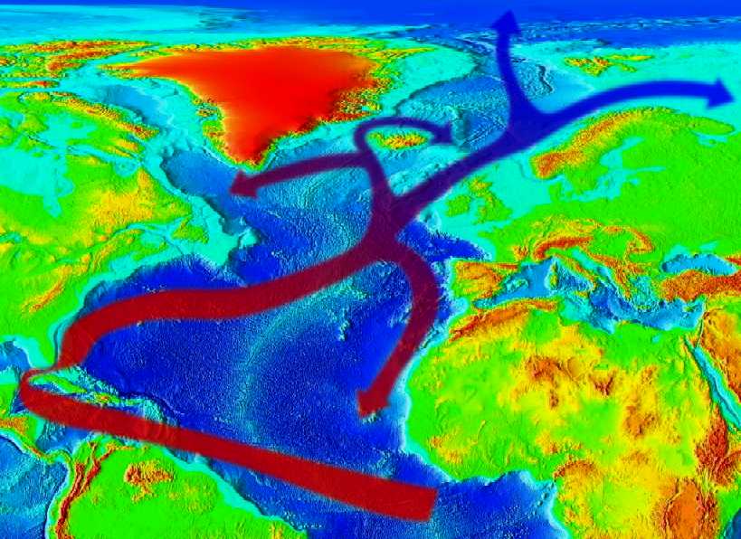
The
Gulf (Golfstream) Stream
ACIDIFICATION
- ADRIATIC
- ARCTIC
- ATLANTIC - BALTIC
- BAY BENGAL - BERING
- CARIBBEAN - CORAL - EAST
CHINA
ENGLISH CH
-
GOC - GULF
GUINEA - GULF
MEXICO
- INDIAN
-
IOC
- IONIAN
-
IRC - MEDITERRANEAN -
NORTH SEA - PACIFIC
- PERSIAN GULF
RED
SEA - SEA
JAPAN - STH
CHINA - PLASTIC
- PLANKTON - PLASTIC
OCEANS - SEA
LEVEL RISE - UNCLOS
- UNEP
WOC
- WWF
AMAZON
- BURIGANGA - CITARUM -
CONGO -
CUYAHOGA
-
GANGES - IRTYSH
- JORDAN -
LENA -
MANTANZA-RIACHUELO
MARILAO
- MEKONG -
MISSISSIPPI -
NIGER -
NILE -
PARANA -
PASIG -
SARNO - THAMES
- YAMUNA -
YANGTZE -
YELLOW -
ZHUJIANG
LINKS
& REFERENCE
Wikipedia
Caribbean_Sea
The
Economist Black Storm
Rising Bloomberg
Gulf of Mexico Gulf
Council Gulfmex Wikipedia
Gulf_of_Mexico Wikipedia
Blowouts_well_drilling notable_offshore
Wikipedia
List_of_oil_spills
Wikipedia
International_Convention_for_the_Safety_of_Life_at_Sea http://www.economist.com/node/16059982
http://topics.bloomberg.com/gulf-of-mexico/
http://www.gulfcouncil.org/
http://www.gulfmex.org/
http://en.wikipedia.org/wiki/Gulf_of_Mexico
http://en.wikipedia.org/wiki/Blowout_%28well_drilling%29#Notable_offshore_well_blowouts
http://en.wikipedia.org/wiki/List_of_oil_spills
http://en.wikipedia.org/wiki/International_Convention_for_the_Safety_of_Life_at_Sea
http://en.wikipedia.org/wiki/Caribbean_Sea
LORD
HUNTINGTON - a prominent member of the British Geographical Society, acquires an ancient parchment on the deathbed of a famous explorer, handed down through
generations, father to son, which contains clues to the location of pirate,
Henry
Morgan's accumulated treasure trove on an Island in the Caribbean, said to be guarded by a macabre human spirit manifesting itself as human skull. More to the point these islands are patrolled by the US and South American navies who are in a cold war situation.
Huntington hires John Storm for his expertise in marine archaeology as a consultant to the expedition and the
Elizabeth Swan, a solar powered ship, for its stealth cloaking ability making the boat invisible to radar.
They find the Island avoiding contact with any of the Bolivarian Republic's (of Venezuela) warships which might arouse curiosities but despite all efforts to keep the reason for the expedition a secret, the word is leaked out by a one of Huntington's arch rivals to a corrupt naval officer, who engages a cutthroat gang of mercenaries to steal the treasure and glory for himself.
The treacherous rival gang soon invades the Island intent on getting the treasure for themselves, having first sabotaged the
Elizabeth Swan .......... or so they thought ....
CONTACTS
| OCEANS
|