|
The Euro-Mediterranean Center on Climate Change (CMCC) is a new Italian research centre dedicated to climate and climate related research, including climate variability, its causes and consequences, carried out through numerical models ranging from Global
Earth System to Regional models within the Euro-Mediterranean area.
FOUNDATION
The centre has been established with initial funding by the
Italian Ministries for: Economy and Finance; Environment, Land and Sea; University and Research, within the Strategic Programme “Sustainable development and climate change” of the 2001 Special Integrative Fund for Research (FISR), aimed at funding specific activities with exclusive strategic relevance, pursuant to the 2001–2003 (also extended to 2005–2007) National Research Programme (PNR). As such, the CMCC fulfils the “creation of an international level centre for research on climate change” with focus on the: “development and in-depth examination of knowledge on climate variability: study of causes and consequences through high resolution simulations”.
The CMCC started its operations in mid-2005. The official opening of CMCC facilities has been put off at the beginning of 2009, coinciding with the “Climate Science in the Mediterranean area” event, which took place in Lecce, on 31 January 2009.
STRUCTURE
The CMCC is a Ltd Company (CMCC S.c.a.r.l.) with its headquarters based in Lecce and local units in Bologna,
Venice, Capua, Sassari and Milan, to exploit the existing expertise of its partners. The CMCC is operated by a Research Consortium consisting of different Italian public and private research Institutions, led by the “Istituto Nazionale di Geofisica e Vulcanologia” (INGV). The legal address of CMCC is:
(CMCC) Centro Euro-Mediterraneo per i Cambiamenti Climatici – S.c.a.r.l. Via Augusto Imperatore, 16 – I-73100 Lecce (LE), Italy.
The Director of CMCC is Dr. Antonio Navarra.
PARTNERS
Partners
Istituto Nazionale di Geofisica e Vulcanologia (INGV)
Università degli Studi del Salento
Centro Italiano Ricerche Aerospaziali (CIRA)
Consorzio Venezia Ricerche (CVR)
Fondazione Eni Enrico Mattei (FEEM)
Università degli Studi del Sannio
Associated centres
Consiglio Nazionale delle Ricerche (CNR) – Dipartimento Ambiente
Università della Tuscia
Istituto Agronomico Mediterraneo di Bari
Centro di Ricerca in Matematica Pura e Applicata – CRMPA
Università degli Studi di Sassari
INDIA SAMVAD JANUARY 2016
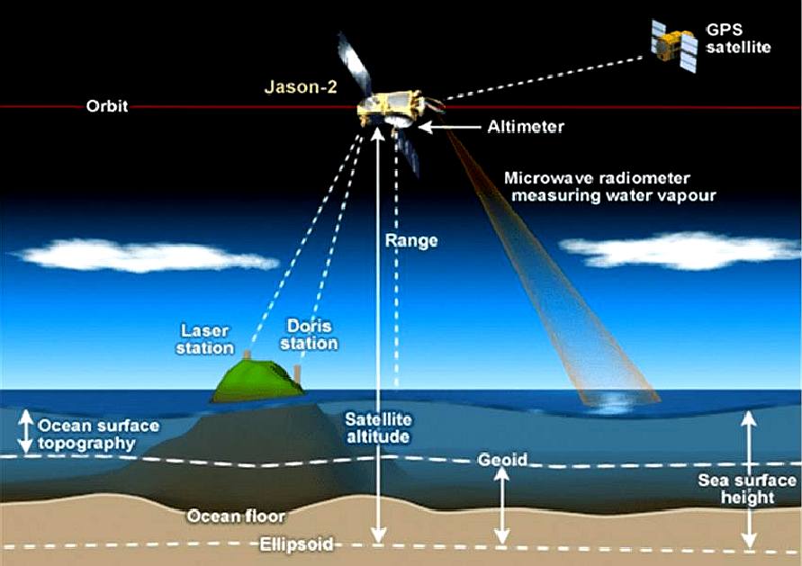
- Washington: A key ocean-monitoring satellite on board a SpaceX Falcon 9 rocket was launched from the Vandenberg Air Force Base in California on Sunday that will continue a nearly quarter-century record of tracking global sea level rise.
The international mission Jason-3, a US-European oceanography satellite mission with NASA participation, will continue to monitor and precisely measure global sea surface heights, observe the intensification of tropical cyclones and support seasonal and coastal forecasts, the US space agency said in a statement.
Jason-3 data will also benefit fishery management, marine industries and research into human impacts in the world's oceans. The mission is planned to last at least five years.
“Jason-3 will take the pulse of our changing planet by gathering environmental intelligence from the world’s oceans,” said Stephen Volz, assistant administrator for NOAA’s Satellite and Information Service.
The $180-million mission will improve weather, climate and ocean forecasts, including helping NOAA’s National Weather Service and other global weather and environmental forecast agencies more accurately forecast the strength of tropical cyclones.
“The measurements from Jason-3 will advance our efforts to understand Earth as an integrated system by increasing our knowledge of sea level changes and the ocean’s roles in climate,” added John Grunsfeld, associate administrator for science at the NASA headquarters in Washington, DC.
Minutes after Jason-3 separated from the rocket’s second stage, the spacecraft unfolded its twin sets of solar arrays.
Ground controllers successfully acquired the spacecraft’s signals, and initial telemetry reports showed the satellite was in good health.
The international mission Jason-3 is led by the NOAA partnering with the US space agency
NASA, CNES (the French Space Agency) and the European Organisation for the Exploitation of Meteorological Satellites.
OBJECTIVES
The mission of the CMCC is "to improve our understanding of the nature and mechanisms of climate variability, its causes and its impacts, with a special emphasis on the Mediterranean area" and its interactions with the global climate. Through the capabilities of its members and associate centres, the CMCC delivers scientific-technical products and technical support to Ministries, Regions and Provinces and the private sector in fields such as:
* climate change assessments;
* the protection of the marine environment of the Mediterranean Sea towards a sustainable use of the resources;
* ecology, forestry science, health and economy;
* risk management (natural hazards related to climate, oil
spills, coastal euthrophication, water resources, etc.);
* transportation, agriculture, energy and tourism.
Furthermore, through satellite remote sensing, the CMCC also aims to carry out:
* the monitoring of the eco-environmental resources (water, agriculture, forestry);
* the analysis and prevention of the risks due to natural and anthropogenic hazards;
* the monitoring of the energy and transportation networks.
International cooperation is an essential activity of the CMCC, which financially supports several international projects, and participate to
European projects and works within bilateral agreements between Italy and other Countries. Other than operating research coordination/management of international projects led by Italian Ministries, the CMCC also provides scientific support for several multilateral international activities, including IPCC, UNCCD, UNEP and UNFCCC.
In 2008–2009, CMCC also supports the Italian G8 Presidency with scientific and technical advice, including for the organization and management of three workshops on
climate change related issues. The centre also contributes to knowledge dissemination through specific events (seminars, conferences, congresses or workshops) and educational activities, with the preparation, funding and management of training programs (on a post-doctoral level), such as PhD Schools and Summer and Winter
schools.
CIGODAS
– The CMCC-INGV Global Ocean Data Assimilation System
Division ODA - Ocean modeling and Data Assimilation
[This is a model used in the past]
The Global Ocean Circulation model NEMO is currently used together with two multivaried assimilation schemes, Optimal Interpolation (OI) and variational, which are able to assimilate more types of observations and correct several physical variables.
Both systems are based on a technique of reduction of the dimension of the problem that uses a set of multivaried vertical EOFs where the state vector of the model is projected.
The following CMCC Research Paper contains the guide that describes the system of assimilation based on the OI and explains how to use it.
Research Papers: RP0071 - The CMCC-INGV Global Ocean Data Assimilation System (CIGODAS)
CLIMATE NEWS NETWORK FEB 2015
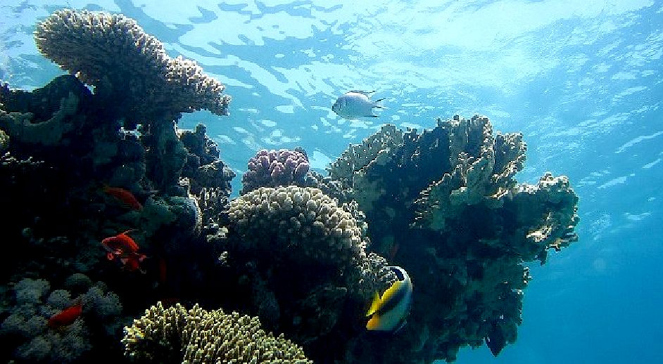
- LONDON, 25 February, 2015 − Climate scientists are looking for a new perspective on the increasingly acidic oceans through a suite of satellites 700 km out in space, watching over parts of the seas that research ships cannot reach. They report in the journal Environmental Science and Technology that thermal cameras could measure ocean temperatures, while microwave sensors could measure ocean salinity. Together, the two sets of data could help answer, cheaply and easily, questions about the chemistry of the oceans – and in particular changes in pH, the index of acidity. Until now, researchers have depended on specialist instruments or shipboard samples to provide answers to huge questions about the oceans’ increasing uptake of carbon dioxide. Such research is costly and limited. But ocean science has become ever more important. Each year, 36 billion tonnes of CO2 are released into the atmosphere, and about a quarter of this gets into the oceans.
Greenhouse gas
- That’s a good thing: if it did not, global warming would accelerate at an even greater rate. But the same global transfer of greenhouse gas also delivers a stronger solution of carbonic acid to the oceans, and ocean acidity levels have risen by 26% over the last 200 years. The consequences for all those sea creatures that evolved to exploit ocean chemistry to build shells or skeletons are uncertain, but the evidence so far is that changes can affect fish behaviour, shellfish reproduction, and coral growth. The changes could almost certainly affect fisheries in the short term, and in the long term could possibly alter the continuous and vital exchanges between atmosphere and ocean that controls the climates of continents. So marine scientists launched a Global Ocean Acidification Observing Network to assemble worldwide expertise and find new ways to monitor change.
“We are pioneering these techniques so that we can monitor large areas of the Earth’s oceans”
“Satellites are likely to become increasingly important for the monitoring of ocean acidification especially in remote and dangerous waters like the Arctic,” says one of the report’s authors, Jamie Shutler, an oceanographer at the University of Exeter. UK. “It can be difficult and expensive to take year-round direct measurements in such inaccessible locations. We are pioneering these techniques so that we can monitor large areas of the Earth’s oceans, allowing us to quickly and easily identify those areas most at risk from the increasing acidification.”
The new approach will exploit a number of existing satellites, along with the European Space Agency’s Soil Moisture and Ocean Salinity sensor (SMOS), launched in 2009, and the US space agency NASA’s Aquarius satellite, launched in 2011. The satellites cannot, of course, directly measure ocean pH values, but the capacity of CO2 to dissolve in water is controlled by ocean temperatures.
Salinity levels - On the other hand, salinity levels play into the capacity to form carbonates. Chlorophyll levels in the oceans also indicate the rates at which biology can exploit any of the dissolved carbon dioxide. If the scientists have temperature and air pressure data as well, they have enough to begin to calculate the rates at which any stretch of sea might be acidifying. Although such measurements are indirect, and involve complex mathematical calculation, the results can be checked in some places against real-time data from a network of autonomous instruments called Argo, and by shipboard laboratory studies. But satellites are about the only way of making consistent measurements of the desolate and hostile Arctic and Indian Oceans. They could also help researchers understand the changes taking place in complex stretches of sea such as the Bay of Bengal and the Greater Caribbean. The research is in its infancy. But the authors say that satellite studies − supported by good measurements taken directly at sea − could become a key element in understanding and assessing the acidification of the oceans.
By Tim Radford
NEMO
NEMO – Nucleus for European Modelling of the Ocean
Divisions: ODA - Ocean modeling and Data Assimilation, ASC - Advanced Scientific Computing Division, OPA - Ocean Predictions and Applications
NEMO (Nucleus for European Modelling of the Ocean, www.nemo-ocean.eu/) is a pan-European community ocean-modeling framework owned and maintained by a consortium of institutes including the CMCC. It is in use in a wide variety of applications whose prime objectives are oceanographic and climate research, operational ocean forecasts and seasonal weather forecasts.
The system consists of three principal engines
1. OPA (Océan Parallélisé), the blue ocean, for modeling the ocean dynamics;
2. LIM (Louvain-la-Neuve Sea Ice Model), the white ocean, for modeling sea-ice thermodynamics and dynamics;
3. TOP (Tracer in the Ocean Paradigm), the green ocean, for modeling marine biogeochemistry.
NEMO also includes the AGRIF package for adaptive grid refinement and assimilation components (tangent linear and adjoint models TAM, observational operator OBS, and application of the analysis increment ASM).
NEMO can also be interfaced to a number of other components such as atmospheric models or alternative models of sea-ice and biogeochemistry, to enable Earth system modeling. Engines are nested in environments, which involve, for instance, reference configurations, pre- and post-processing tools, interface to other Earth-System components and documentation of the system.
NEMO is available as a source code and agreement of the free license.
The NEMO system evolve through the improvement of the existing engines or the creation of new ones, the addition of new components coming from other models and their interface to NEMO, and the improvement and generalization of the environment. These evolutions are driven by an annual work plan elaborated within the NEMO Consortium.
All CMCC research of climate and ocean are based on the ocean general circulation model OPA. It is a finite difference, hydrostatic, primitive equation ocean general circulation model, with a free sea surface and a non-linear equation of state. OPA describes the distribution of variables in a 3D Arakawa C grid centered at tracer points. Prognostic variables (directly solved by the model equations) are the temperature, the salinity, the sea surface height and the 3D velocity fields.
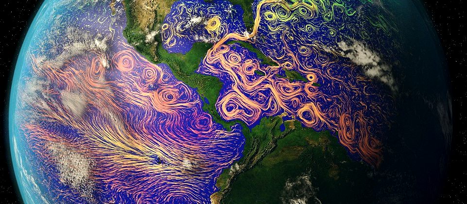
DAILY MAIL APRIL 2016 - These images might look like more like something out of a Vincent Van Gogh painting than scientific photographs.
But this is no starry night. The stunning images were taken by satellites before the paths and temperatures of the world's ocean currents were mapped onto them.
From the chaotic Atlantic to the mighty Pacific, the newly released pictures show the world’s ocean currents as you’ve never seen them before.
The technicolour swirls show the variety of temperatures, from cool greens in the poles to the red of the warm tropics near the equator.
The images were created by layering ocean current data compiled by Nasa with photographs taken by various satellites orbiting the planet.
Coastal currents near land are affected by local winds, but surface ocean currents, like those pictured in these images, occur on the open ocean and are driven by a complex global wind system.
Space agencies like Nasa and Esa monitor the ocean temperatures using satellites as part of their efforts to
monitor changes to the climate and the world's ecosystems.
'Satellites offer a frequent overview of our entire planet – covered mostly by water – and provide valuable data to monitor and understand global ocean circulation,' a post on the
ESA website says. 'Understanding water currents at the ocean surface is important for many applications.'
The way it works is simple - the ocean emits radiation in the infrared and the microwave wavelengths, and the amplitude of these wavelengths vary with the temperature of the ocean so can be used to measure it.
C-GLORS – The CMCC Global Ocean Physical Reanalysis System
Division ODA - Ocean modeling and Data Assimilation
The CMCC Global Ocean Physical Reanalysis System (C-GLORS) is used at CMCC to simulate the state of the ocean in the last decades. It consists of a variational data assimilation system (OceanVar), capable of assimilating all in-situ observations along with altimetry data, and a forecast step performed by the ocean model NEMO coupled with the LIM2 sea-ice model.
C-GLORS is currently implemented in a 1/2 degree resolution and a 1/4 degree resolution configurations, both using 50 vertical levels. The former is mainly used for testing purposes, long-term simulations and ensemble simulations, while the latter for the production of reanalyses in the last two or three decades, in the framework of MyOcean and GEMINA projects.
RESEARCH HEADS
The activities of the CMCC are carried out by and clustered into six different topical Research units:
*
ANS
Numerical Applications and Scenarios
*
CIP
Climate Impacts and Policies. An Economic Assessment.
*
FDD
Education, Documentation and Dissemination
*
IAFENT
Impacts on Agriculture, Forest, and Natural Ecosystems
*
ISC
Impact on Soil and Coast
*
SCO
Scientific Computing and Operations
The
CMCC also hosts the working group of the IPCC National Focal Point for
Italy.
CONTACTS


Fondazione Centro Euro-Mediterraneo sui Cambiamenti Climatici
via Augusto Imperatore 16
73100 Lecce, Italy
Tel. +39 0832 288650
Fax +39 0832 277603
Email: info@cmcc.it
PEC: cmcc@pec.lapostacert.it


LINKS
CNRS
(France),
Mercator-Ocean
(France),
NERC
(UK)
Met
Office (UK)
CMCC
(Italy)
INGV(Italy) http://www.indiasamvad.co.in/environment/key-ocean-monitoring-satellite-to-measure-global-sea-level-rise-launched--10358 http://climatenewsnetwork.net/satellite-link-puts-sharper-focus-on-ocean-acidity-rise/ http://www.nemo-ocean.eu/ http://www.cmcc.it/models/nemo http://www.cmcc.it/c-glors/ http://www.dailymail.co.uk/sciencetech/article-3547559/Technicolour-swirls-varied-temperatures-ocean-currents-satellite-images-look-like-art-science.html https://www.cmcc.it/models/cigodas-the-cmcc-ingv-global-ocean-data-assimilation-system http://www.climatescienceandpolicy.eu/ https://en.wikipedia.org/wiki/Euro-Mediterranean_Center_on_Climate_Change
ACIDIFICATION
- ADRIATIC - ARCTIC
- ATLANTIC - BALTIC
- BAY BENGAL - BERING
- CARIBBEAN - CORAL
- EAST CHINA
SEA
ENGLISH
CH - GOC
- GULF GUINEA - GULF
MEXICO - INDIAN -
IOC
- IRC
- MEDITERRANEAN - NORTH
SEA - PACIFIC - PERSIAN
GULF - SEA JAPAN
STH
CHINA - PLASTIC
- PLANKTON - PLASTIC
OCEANS - SEA
LEVEL RISE - UNCLOS
- UNEP
WOC
- WWF
AMAZON
- BURIGANGA - CITARUM - CONGO -
CUYAHOGA - GANGES - IRTYSH -
JORDAN - LENA - MANTANZA-RIACHUELO
MARILAO
- MEKONG - MISSISSIPPI - NIGER - NILE - PARANA - PASIG - SARNO - THAMES
- YANGTZE - YAMUNA - YELLOW
|