|
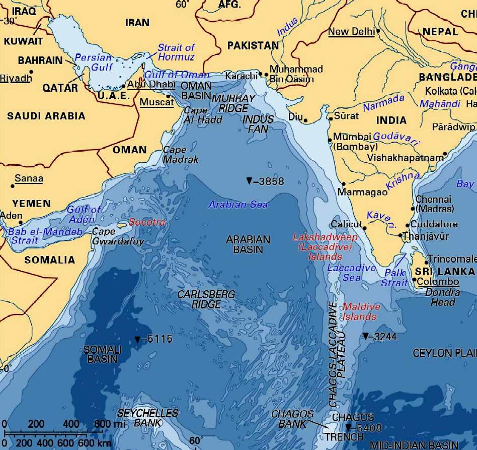
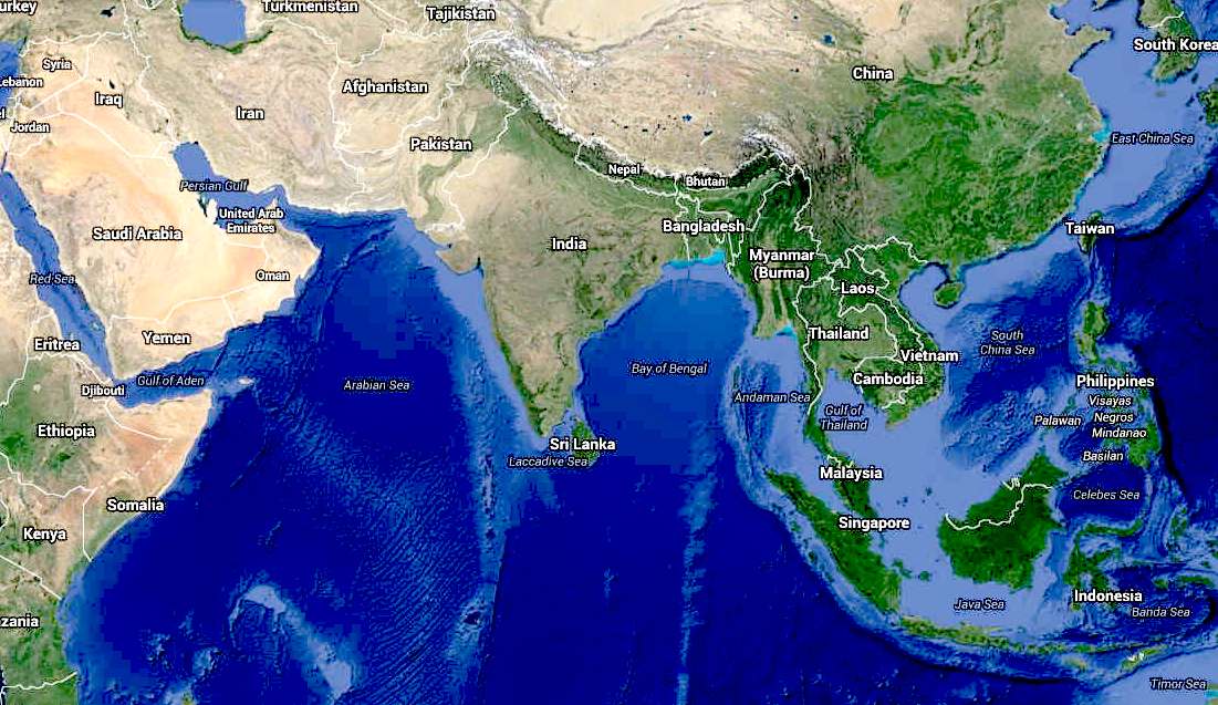
Map
of the Arabian Sea

THE THIRD POLE - JUNE 8 2016
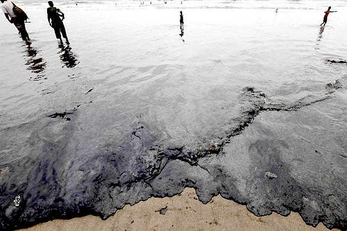
- Karachi’s catastrophic pollution of the sea
Untreated waste and oil spills from the city’s two ports endanger marine life and the livelihood of Pakistan’s fishermen.
The team of five exhausted fishermen have just return from a three day tiring journey of the Arabian Sea. After anchoring their wobbly 30-foot boat at the fishing jetty of Karachi’s historical
fishing settlement, Ibrahim Hyderi, they started unloading nets and emptying the plastic baskets. Finally they piled up their catch, which comprises small fish. The three nights of labour will earn each fisherman PKR 3,000 (USD 30), as only fish meal factories will buy it for less than the market rate.
“There are no fish near the shores and we have to travel into open sea to find the catch,” said Abass Mallah, the forty-year-old captain of the boat.
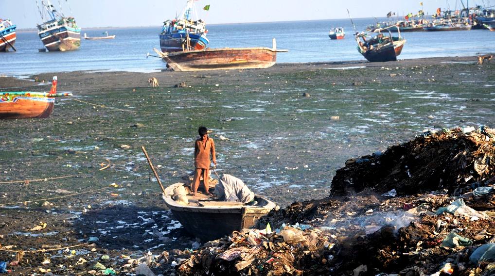
The residents in this oldest fishing village are running out of luck as they have to find ways to survive with the growing pollution from Pakistan’s largest city. These days they need powerful motorboats, bigger fishing nets and extra men to sail into the open sea and spend several days in search of fish.
“Dumping of garbage and pouring sewerage water into sea has badly affected fish,” said Saleh Muhammad, a fisherman from the village.
Just a few yards away from the fishing jetty, heaps of rubbish have been dumped on the beach. According to locals, influential people have started inviting rubbish trucks to come and dump municipal waste into the sea. They hope then to lay claim to the adjacent land, and sell it at a large price.
Just outside the village, there is a huge drain. It pours forth smoky black water, layered with white foam, into the sea. This effluent comes from the city. There are six industrial zones in Karachi with around 10,000 industrial units that manufacture everything from textiles to chemicals and paints. The most polluting, in terms of chemical waste, are the tanneries.
The authorities admit that solid waste and toxic industrial effluents are dumped into sea, untreated. Sindh Minister for Environment, Sikandar Mandhro, said that he is aware that the waste water and solid waste is dumped into the sea. “This is not new phenomena, we have chalked out a plan to solve the issue on a permanent basis,” he said.
Authorities estimate that Karachi produces around 500 million gallons per day (MGD) of waste water. Around one fifth of water comes from these industries, while the rest is the domestic or municipal sewerage. “Almost the entire sewerage and industrial waste water goes into sea without treatment, which has brought a natural disaster, as we are losing our fish catch and also it is affecting marine life. We are working to resolve the issue,” admitted Mandhro.
According to the law the owners of industrial units are responsible for treating industrial waste and disposing of the waste water properly without harming the environment. “There was no law to punish the polluters in the past, but now we have introduced new laws and will soon ensure that every industry treats its waste,” said Mandhro.
However, factory owners have different ideas. “Most of the industries were built five or six decades ago and now they have no space to build treatment plants inside the factories,” said Syed Sadiq Ahmed, an owner of a small factory in Korangi Industrial area. He said the government has a plan to treat the industrial waste water but nothing yet has been done. “A huge treatment plant was started in Korangi Industrial area, but is no longer functional,” he said.
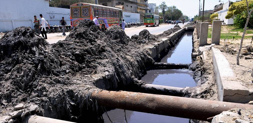
There are no designated landfill sites in Karachi, therefore the rubbish or solid waste, which includes plastic, is thrown directly into the sea or dumped in rainwater steams or nullahs and ultimately are washed into the sea after monsoon floods.
According to data collected by the Sindh Environmental Protection Agency (SEPA), there is also the waste from, the huge local cattle colony, which houses around a million animals, a mix of cows and buffaloes. The waste produced by them is also dumped in the sea.
Pakistan’s only two functional ports – Karachi Port and Bin Qasim Port – are also located on these shores, which also contribute to the pollution. The Karachi Port Trust (KPT) authorities claim that they are working day and night to keep the sea clean, but the
Pakistan Game Fish Association has termed the port as, “possibly the most polluted port in the world”. Oil spills from the ships in the vicinity are common, and the
Tasman Spirit oil spill in 2003, was
one of the world’s
worst. The Greek oil tanker carrying 67,500 tonnes of crude oil broke ran aground near the Karachi port, killing thousands of fish and birds in the area. The impacts of the spill still linger.
Ecologists are worried about the increasing marine pollution. Nadeem Mirbahar, a renowned ecologist and coordinator at the International Union for Conservation of Nature and Natural Resources (IUCN) Pakistan, said pollution has badly affected the fish catch and marine life. “Along the Karachi coast, locals sometimes find corpses of endangered green turtles and other cetaceans, which died because of the pollution, especially due to throwing of plastic waste into the sea,” said Mirbahar. He said that several species of fish have disappeared from the waters of Arabian Sea due to pouring of industrial waste.
Amar Guriro is Karachi based freelance environmental journalist.
GEOGRAPHY
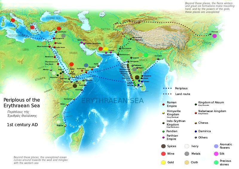
The Arabian Sea is a region of the northern Indian Ocean bounded on the north by Pakistan and Iran, on the west by northeastern Somalia and the Arabian Peninsula, and on the east by India. An ancient name was the Erythraean Sea and Persian Sea.
The Arabian Sea's surface area is about 3,862,000 km2 (1,491,130 sq mi). The maximum width of the Sea is approximately 2,400 km (1,490 mi), and its maximum depth is 4,652 metres (15,262 ft). The biggest river flowing into the Sea is the Indus River.
The Arabian Sea has two important branches — the Gulf of Aden in the southwest, connecting with the Red Sea through the strait of Bab-el-Mandeb; and the Gulf of Oman to the northwest, connecting with the Persian Gulf. There are also the gulfs of Cambay and Kutch on the Indian coast.
The countries with coastlines on the Arabian Sea are Somalia, Djibouti, Yemen, Oman, Iran, Pakistan, India and the Maldives. There are several large cities on the sea's coast including Karachi, Gwadar, Pasni, Ormara, Aden, Muscat, Mumbai, Keti Bandar, Salalah, Duqm and Kochi.
The Arabian Sea has been referred to by many different names by Arab travelers and European geographers to include: Persian Sea, Sindhu Sagar, Erythraean Sea, Sindh Sea, and Akhzar Sea.
ARABIAN SEA ISLANDS
There are several islands in the Arabian Sea, with the largest being Socotra (Yemen), Masirah (Oman), Astola Island (Pakistan) and Andrott (India).
Astola Island, also known as Jezira Haft Talar (Urdu: جزیرہ ہفت تلار) or 'Island of the Seven Hills', is a small, uninhabited island in the northern tip of the Arabian Sea in Pakistan's territorial waters. It is a popular eco-tourism destination in the region. Overnight tourists camp on the island and bring their own provisions. Camping, fishing and
scuba-diving expeditions are popular. It is also a site for observing turtle breeding. Endangered animals such as the green turtle (Chelonia mydas) and the Hawksbill turtle (Eretmochelys imbracata) nest on the beach at the foot of the cliffs. The island is also a very important area for endemic reptiles such as the Astola Viper (Echis carinatus astolae).
Socotra (Arabic: سُقُطْرَى Suquṭra), also spelled Soqotra, is the largest island, being part of a small archipelago of four islands. It lies some 240 kilometres (150 mi) east of the Horn of Africa and 380 kilometres (240 mi) south of the Arabian Peninsula. The island is very isolated and through the process of speciation, a third of its plant life is found nowhere else on the planet. It has been described as the most alien-looking place on Earth.
Masirah (Arabic: مصيرة) is an island off the East coast of Oman. The main industries here are fishing and traditional textile manufacturing. Formerly, traditional ship building was important. The rugged terrain of the island and surrounding rough coastline has led to the appearance of many wrecked dhows on the beaches of the island, most of them well preserved by the salt water and intense heat. The ocean bottom environment surrounding Masirah is hostile as the majority of the area is covered in either sand or hard rock. Despite the poor quality ocean bottom, the area is very productive with marine fisheries, and any hard objects (barrels, engines) are immediately colonized by local fauna.
TRADE ROUTES
The Arabian Sea has been an important marine trade route since the era of the coastal sailing vessels from possibly as early as the 3rd millennium BCE, certainly the late 2nd millennium BCE through the later days known as the Age of Sail. By the time of
Julius
Caesar, several well-established combined land-sea trade routes depended upon water transport through the Sea around the rough inland terrain features to its north.
These routes usually began in the Far East or down river from Madhya Pradesh with transshipment via historic Bharuch (Bharakuccha), traversed past the inhospitable coast of today's Iran then split around Hadhramaut into two streams north into the Gulf of Aden and thence into the Levant, or south into Alexandria via Red Sea ports such as Axum. Each major route involved transhipping to pack animal caravan, travel through desert country and risk of bandits and extortionate tolls by local potentiates.
This southern coastal route past the rough country in the southern Arabian peninsula (Yemen and Oman today) was significant, and the
Egyptian Pharaohs built several shallow canals to service the trade, one more or less along the route of today's Suez canal, and another from the Red Sea to the Nile River, both shallow works that were swallowed up by huge sand storms in antiquity. Later the kingdom of Axum arose in Ethiopia to rule a mercantile empire rooted in the trade with Europe via Alexandria.
MAJOR PORTS
Jawaharlal Nehru Port in Mumbai is the largest port in Arabian sea, and the largest container port in India.
The Port of Karachi (Urdu: بندر گاہ كراچى, Bandargāh-i Karācī) is Pakistan's largest and busiest seaport, handling about 60% of the nation's cargo (25 million tons per annum). It is located between the Karachi towns of Kiamari and Saddar, close to the main business district and several industrial areas. The geographic position of the port places it in close proximity to major shipping routes such as the Strait of Hormuz. The history of the port is intertwined with that of the city of Karachi. Several ancient ports have been attributed in the area including "Krokola", "Morontobara" (Woman's Harbour) (mentioned by Nearchus), Barbarikon (the Periplus of the Erythraean Sea, and Debal (a city invaded and captured by the Muslim general Muhammad bin Qasim in 712 AD). There is a reference to the early existence of the port of Karachi in the "Umdah", by the Arab navigator Sulaiman al Mahri (AD 1511), who mentions "Ras al Karazi" and "Ras Karashi" while describing a route along the coast from Pasni to Ras Karashi.
Karachi is also mentioned in the sixteenth century Turkish treatise Mir'ât ül Memâlik (Mirror of Countries, 1557) by the Ottoman captain Seydi Ali Reis, which is a compilation of sailing directions from the Portuguese island of Diu to Hormuz in the Persian Gulf. It warns sailors about whirlpools and advises them to seek safety in "Kaurashi" harbour if they found themselves drifting dangerously.
The gate facing the sea was called "Kharadar" (salt gate), and the gate facing the Lyari River was called "Mithadar" (sweet gate). The modern neighbourhoods around the location of the gates are called Mithadar and Kharadar. Surrounded by mangrove swamps to the east, the sea to the southwest, and the Lyari River to the north, the town was well defended and engaged in a profitable trade with Muscat and Bahrain.
The Gwadar Port is a warm-water, deep-sea port situated at Gwadar in Balochistan, Pakistan at the apex of the Arabian Sea and at the entrance of the Persian Gulf, about 460 km west of Karachi and approximately 75 km (47 mi) east of Pakistan's border with Iran. The port is located on the eastern bay of a natural hammerhead-shaped peninsula jutting out into the Arabian Sea from the coastline.
Port of Salalah in Salalah, Oman is also a major port in the area. From a modest start in 1997, the Omani container transhipment port has achieved consistent growth. For a growing number of ships’ crew, the port of Salalah is a welcome sight after an unpleasant and often prolonged encounter with pirates. The Port of Salalah is a key container transhipment hub on the Arabian Sea and is often used as the first port of call for vessels whose crew have just been released from the clutches of Somali pirates following ransom payments for withheld vessels and crew. The port also plays host as a supply base for the visiting warships that provide protective escorts for merchant shipping in the sea lanes. From that dual role has emerged another, one as an intelligence network — both military and civilian — to exchange information on possible pirate sightings and near misses. Also, the International Task Force often uses the port as a base. There is a significant number of warships of all nations coming in and out of the port, which makes it a very safe bubble. The port handled just under 3.5m teu in 2009
Major Indian ports in the Arabian Sea are Kandla Port, Nava Sheva, Kochi, Mumbai Port, Kollam Port and Mormugão.
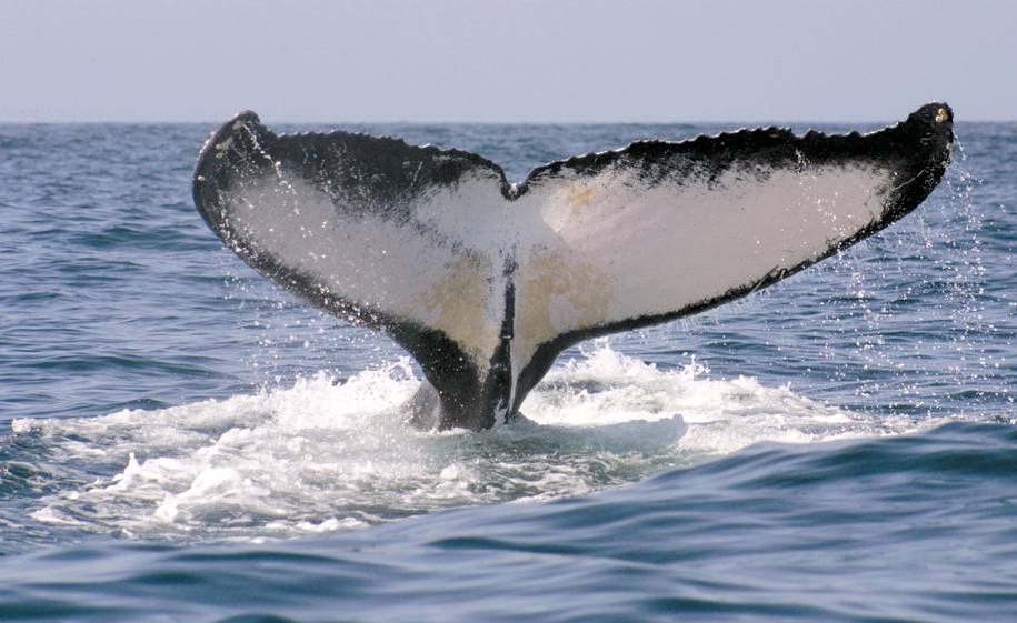
SPITFIRE
- A whale named 'Spitfire' swims in the waters off the island of Hallaniyah in southern Oman. Scientists from WCS,
AMNH, and the Environment Society of Oman have found that humpback whales inhabiting the Arabian Sea are the most genetically distinct humpback whales in the world and may be the most isolated whale population on earth.
HUMPBACK
WHALES
WILDLIFE CONSERVATION SOCIETY (WCS)
Scientists from WCS, the American Museum of Natural History (AMNH), the Environment Society of Oman, and other organizations have made a fascinating discovery in the northern Indian Ocean:
humpback whales inhabiting the Arabian Sea are the most genetically distinct humpback whales in the world and may be the most isolated whale population on earth. The results suggest they have remained separate from other humpback whale populations for perhaps 70,000 years, extremely unusual in a species famed for long distance migrations.
The study appears in the online journal PLOS ONE. The authors include: Cristina Pomilla of the the Sackler Institute for Comparative Genomics at the American Museum of Natural History; Ana R. Amaral of the Universidade de Lisboa; Tim Collins of WCS; Gianna Minton of WWF-Gabon; Ken Findlay of the University of Pretoria; Matthew Leslie of AMNH and WCS; Louisa Ponnampalam of the University of Malaysia; Robert Baldwin of the Environment Society of Oman; and Howard Rosenbaum, Director of the Ocean Giants Program at WCS.
Previous studies on humpback whales, including several published by WCS, have revealed a great deal of population structure among humpback whales of the Northern Hemisphere and many areas of the Southern Hemisphere, particularly on breeding grounds. At the ocean basin scale, scientists are gaining an understanding of humpback whale gene flow, including in the Southern Indian Ocean. The dynamics and movements of animals in the Arabian Sea, however, are poorly understood.
"We have invested lots of energy working to clarify the population structure of several large whale species around the world," said Dr. Howard Rosenbaum, Director of WCS's Ocean Giants Program and senior author on the study. "The levels of genetic differences for Arabian Sea humpback whales are particularly striking; they are the world's most distinct population of humpback whales and might even shed some light on the environmental factors that shape cetacean populations."
To assess the origins of the Arabian Sea humpback whale population, the research team examined nuclear and mitochondrial DNA extracted from tissue samples that were collected as biopsies from 47 individual whales. The data were then compared to existing data sets from humpback whales in both the Southern Hemisphere and the North Pacific. All of the sampling was conducted in the Sultanate of Oman, a known hotspot for the animals. "We couldn't have conducted this study without the magnificent support of the Sultanate of Oman, and particularly our partnership with the Environment Society of Oman," said Collins
The authors have speculated that the 70,000-year separation might be linked to various glacial episodes in the late Pleistocene Epoch and associated shifts in the strength of the Indian Monsoon. The separation is likely reinforced by breeding cycles that are asynchronous; humpback whales in the Arabian Sea breed on a Northern Hemisphere schedule, whereas the closest whale populations in the Western Indian Ocean (below the equator) breed during a different season. The population's known range includes Yemen, Oman, the UAE, Iran, Pakistan and India, and possibly the Maldives and Sri Lanka.
The genetic study also revealed a comparatively low level of genetic diversity when compared to other humpback populations, as well as the signatures of both distant and recent genetic bottlenecks, events caused by population declines. The most recent bottleneck may be due to illegal whaling; during two very short periods in 1965 and 1966 Soviet whalers killed 242 humpback whales in the Arabian Sea (39 of the captured females were also pregnant), a potentially devastating loss for a small population. Today, the major and most urgent concern for this population is lethal entanglement in fishing gear and ship strikes. "This latest study strengthens the evidence that we have an urgent conservation priority to attend to, not just in Oman, but with partners across range states," said HH Sayyida Tania Al Said of the Environment Society of Oman. "We are working with stakeholders in Oman to advocate for the importance of conservation of this species and its consideration in development plans. We are also seeking to work with international partners to improve conservation of marine mammals in the wider Arabian Sea, including participation in a regional humpback whale conservation initiative."
"The Arabian Sea humpback whales are the world's most isolated population of this species and definitely the most endangered," added Rosenbaum. "The known and growing risks to this unique population include ship strikes and fishing net entanglement, threats that could be devastating for this diminished population; we need to see increased regional efforts to provide better protection for these whales."
The current best estimate of population size for Arabian Sea humpbacks is fewer than 100 individuals although this is based solely on the work conducted in Oman. The status of the population is reviewed annually by the Scientific Committee of the International Whaling Commission. The authors of the study recommend that the population be
up-listed from "Endangered" to "Critically Endangered" on the IUCN's Red List of Threatened Species.
HUMPBACKS ENDANGERED NOAA PRESS RELEASE
- SOUTH COAST IMAN
The Dhofar coast of southern Oman is an important habitat for the Arabian Sea population of humpback whales (Megaptera novaeangliae), the only known non-migratory population of humpback whales in the world and one of the most endangered, according to a new modeling study.
In a paper published online October 21 in the journal Endangered Species Research, Peter Corkeron and co-authors suggest a new way to use spatial models with limited data in cetacean conservation planning, using their experience in Oman as an example. Corkeron is a marine mammal researcher at the Woods Hole Laboratory of
NOAA’s Northeast
Fisheries Science Center.
Whale sightings data were collected from small boat surveys off the coast of Oman between 2000 and 2003 by a team led by Robert Baldwin of the Environment Society of Oman (ESO). Surveys were primarily for photo-identification and genetic sampling in areas where the Arabian Sea population of humpback whales were likely to be found, and places that were relatively easy to survey. These whales are members of the smallest humpback population known to exist, and are the only humpbacks that do not undertake extensive seasonal migrations.
Designated as Endangered in 2008 in the IUCN Red List for cetacean species, the Arabian Sea humpback population is estimated at less than 100 individuals. Its distribution includes the waters of Pakistan, India, Iran and Yemen, but there is little or no survey data from these areas. Analysis of photo-identification work and genetic samples conducted by the ESO team has shown that this population is completely isolated from the nearest Indian Ocean population. IUCN, the International Union for Conservation of Nature, is the world’s oldest and largest global environmental network.
Assessing the distribution of humpbacks in three areas off Oman allowed the researchers to make some recommendations about the relative importance of particular areas as habitat for the whales. During the four-year field study, researchers surveyed regularly off the coast of Muscat, during October and November in the Gulf of Masirah, and during February and March off the Dhofar coast. The authors suggest ways to start conservation planning to lessen impacts on humpback whales in that particular area.
“Relatively simple spatial models can provide the scientific basis for conservation planning and management actions,” said Corkeron, lead author of the paper. “Small marine mammal populations, with little or no reliable data on human-related mortality and limited resources to study them, are a common problem in most of the world. Using what data we have for conservation planning can initiate positive steps forward.”
“There are likely many animal populations around the world where considerable data has been collected but isn’t being fully used because it falls outside the standard practices of modeling,” Corkeron said. “The demands of photo-identification mean that you can end up with sightings data that are somewhat biased, simply due to how the photos are collected. This modeling technique uses some sophisticated mathematics to remove some of that bias, making the final model of whales' space use more reliable. And because the technique runs in R, the Open Source statistics language, anyone who understands R can run the same sort of model on their own data, for free.”
Corkeron has studied humpback whales for almost three decades, but only became involved in the work in Oman in 2010, and returned in March of this year. As a proof of concept, he deployed a marine acoustic recording unit (MARU) from Cornell University's Bioacoustic Research Program identical to those used by colleagues off the Northeast U.S. coast to study endangered North Atlantic right whales. The MARU recorded whale sounds in a remote coastal area of Oman not far from the border with Yemen.
“It was an amazing experience,” Corkeron recalls. “We saw humpbacks, Bryde's whales, a couple of blue whales, and heard sperm whales.” As the team of three pulled up to a campsite that the ESO team had identified as being a promising location for whale sightings, Robert Baldwin saw whales before the car had even stopped. “In one day on the water, we collected seven biopsies and photo-identified eight humpback whales.”
Corkeron, who now heads the large whale research team in the Center’s Protected Species Branch, sees many similarities between the problems facing North Atlantic right
whales in local waters, and the humpbacks off Oman. He hopes to be able to return to Oman to continue the work. Despite the remoteness of the location, Corkeron says much work remains to be done.
SILENT
OIL SPILLS
The ‘silent oil spill’ could prove to be a major threat to the Arabian Sea and every country must contribute to counter this problem, according to the commanding officer of the visiting pollution control vessel from the Indian Coast Guard.
“I saw brown sea outside Oman and I assume that could be because of ships washing and dumping oil before entering the port here,” said Donny Michael, Deputy Inspector General of Indian Coast Guards and Commanding Officer of ICGS Samudra Prahari, which arrived at Port Qaboos on Thursday for a four-day visit to Muscat.
He agreed that Oman had strict procedures to control environment pollution on land and around ports. “It is time the coast guard in Oman included the task of monitoring marine pollution in their charter,” said the Indian coast guard officer.
“So far so good,” he said, in reply to a question about the marine environment around Oman. However, he added that it was also necessary to control ships dumping oil outside Omani waters.
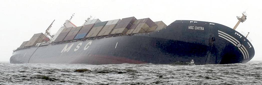
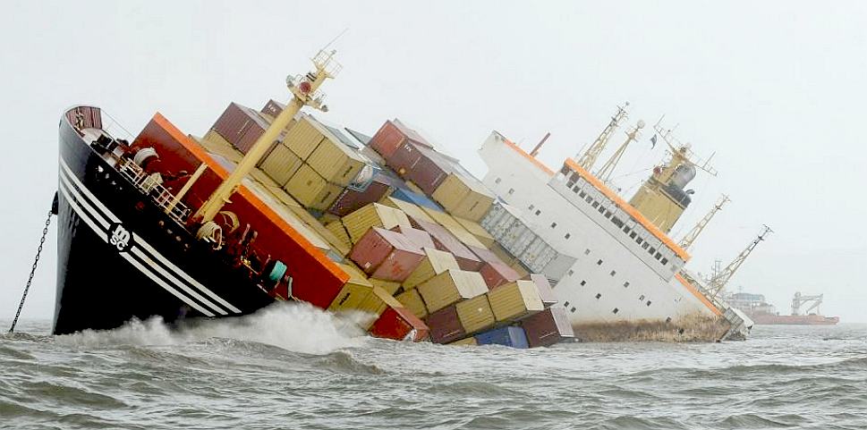
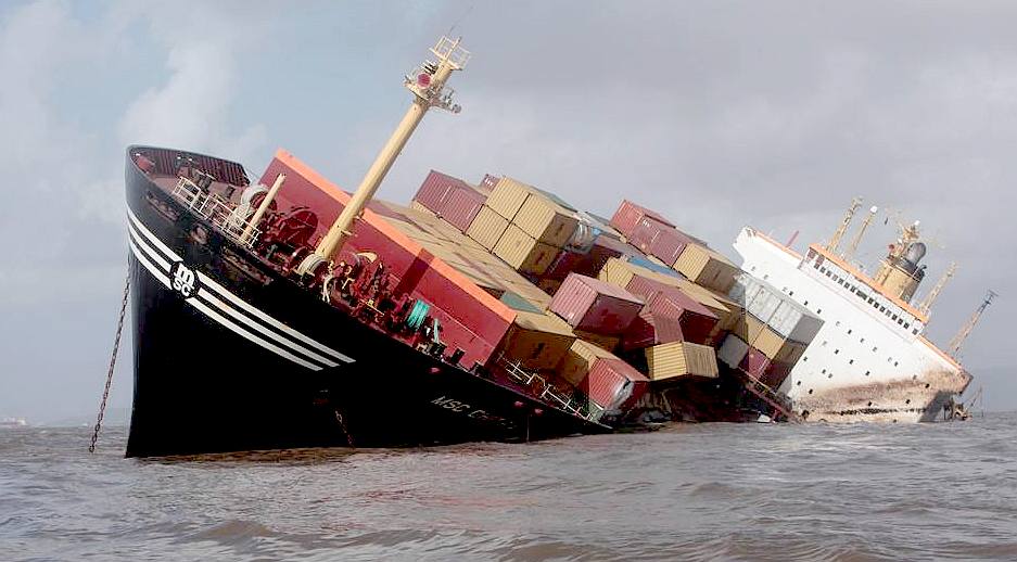
Abandoned ( Panamanian-registered container ship MSC Chitra collided with the
MV-Khalijia-II, a St. Kitts registered ship, tilts in the Arabian Sea, close to
Mumbai, India.
ARABIAN
SEA SHIP SINKINGS
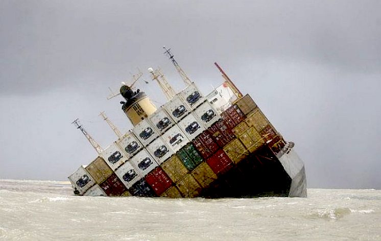
JUNE 2015 MUMBAI - MV COASTAL PRIDE
Fourteen crew members were rescued from a cement carrier which sank in the Arabian Sea off Gujarat on Wednesday in stormy weather, an official said here.
M.V. Coastal Pride sent out a distress signal after its engines failed around 25 km west of Dahanu in Maharashtra on Tuesday evening.
The Indian Navy and Indian Coast Guard had directed the ship to anchor even as towing arrangements were being made.
But around 8.40 a.m. on Wednesday, the ship sank in the Daman coast, around 75 nautical miles north of Mumbai.
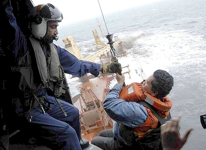
The Indian Navy mounted a rescue operation with ships INS Shikra, INS Colaba and a Seaking helicopter along with the Coast Guard's two Chetak helicopters and rescued all the 14 crewmen safely.
Two days ago, the Maritime Rescue Cooridation Centre Mumbai handled a distress call from a newly constructed vessel whose towline broke while it was being towed from Shanghai to Abu Dhabi.
In another emergency, 25 containers fell off from two ships, including 20 from M.V. MOL Cosmos and five from TCI Arjun.
On Monday, braving the rough sea, heavy rains and poor visibility, the navy and Coast Guard had rescued 20 crew members from a stranded ship M.V. Jindal Kamakshi off Palghar in northern Maharashtra.
AUGUST
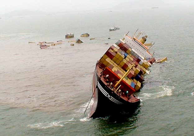
2010 - MV RAK SINKING
The motor vessel RAK was a ship carrying 60,000 tonnes of coals and oil,
was steaming toward Mumbai when the vessel sunk in the Arabian Sea. 30
people were rescued from ship.
Indian shipping authorities ordered an inquiry into the sinking cargo ship M.V. Rak Carrier with an international crew that was struck off the Mumbai coast in the Arabian Sea Thursday morning.
The Indian Coast Guard (ICG) rescued all 30 crewmen from the Panamanian flagged ship which sent out a distress call around 8 a.m. to the Indian maritime authorities after a suspected leakage led to heavy flooding.
The DGS has also served a notice to the Panama maritime authorities, from where the vessel was registered and to the ship owners, manager and local agent under provisions of Merchant Shipping Act, 1958.
The Mumbai Port Trust and National Hydrographic Officer, Dehradun, were told to issue navigational warning about the 225 metre long ship, three-fourths of which is now sunk.
All concerned agencies like the Mumbai Collector, Maharashtra Pollution Control Board, Director-General of Lighthouse & Lightships, the two port authorities and others were informed to initiate appropriate action against the ship owners and insurers.
The ship, owned and managed by M/s. Delta Shipping Marine Services, was carrying 290 tons of fuel oil and another 50 tons of diesel. It was on a voyage from Lubuk-Tutung, Indonesia to Dahej Port, Gujarat, carrying 60,000 tons
coal cargo.
The crewmen included Indonesians, Jordanians and Romanians.
The ICG and other agencies concerned with maritime safety immediately dispatched two helicopters and a smaller vessel to the sinking ship, anchored around 25 nautical miles off south Mumbai.
"Within a couple of hours, we succeeded in rescuing all the 30 crewmen, including 11 who had jumped into the sea. They have been brought ashore to Mumbai," ICG spokesman R.V. Prasad told IANS.
A coast guard ship, Samudri Prahar, which was in the vicinity, was diverted to the disaster site to coordinate relief operations.
Now, it will remain in the areas to monitor the situation and check whether the ship could pose environmental hazards, Prasad said.
By early afternoon, the ICG and the Indian Navy rescued all the crew, 18 of whom were shifted ashore by a naval helicopter and the rest by a merchant navy ship.
MARINE
INSIGHT FEB 2011
August
2010 saw the collision of two cargo ships MSC Chitra and MV Khalijia off the Mumbai coast. The collision resulted into spilling of containers and oil along the full coastline. MSC Chitra, which was carrying 1219 containers, 2662 tons of fuel, 283 tons of
diesel, and 88040 litres of lubricating oil, capsized and sank into the sea, creating maximum damage to the area.
Several questions were raised and many assumptions were made while deciphering the real reason behind the collision. In this article, Adelbert Pereira, Chief Officer from Mumbai, lists down the probable factors behind the untoward collision, which could have been easily averted.
MAIN REASONS FOR MSC CHITRA AND KHALIJIA
Reason 1 : Non compliance of Rules of the Road (ROR) or Navigational rules
1) As per rule 9d, vessel should not cross a narrow channel or fairway if such a crossing impedes the safe passing of the vessel that can safely navigate within a narrow channel or fairway.
M/V Khalija should have waited until MSC Chitra was out of the channel. Moreover, MSC Chitra should have sounded the wake-up call of 5 short and rapid blasts.
2) As per rule 9a, vessel using a narrow channel or fairway shall leap near to the outer limit of channel or fairway that lies to her starboard side is as safe as practicable.
M/V Khalijia for some inexplicable reason altered course and wanted to go to port reasons. The reasons for these could be steering failure, wrong applications of rules, misjudging the maneuvering characteristics of the vessel, confusion due to close proximity, and lack of experience.
3) The prevailing ROR situation also demanded application of rule 2 b. Rule 2 states that no one should rely on the rules alone to keep them out of danger.
You must obey the rules, but if you’re getting into a CQS then you may disobey the rules so as to minimize damage to your ship.
After MSC Chitra saw Khalijia taking a wrong action of going to port she should have taken adequate evasive action. The inability to take action shows lack of good seamanship. Moreover, there was also no use of sound signalling apparatus.
4) Non observance of rule no.5 -look out – Both ships failed to maintain an efficient look out
5) Non observance of safe speed rule no.6 – As both vessels were entering / exiting the channel they should have proceeded at a safe speed.
Reason 2 : Contraventions of Merchant Shipping Act (MSA) section 285
Section 285 states that Indian government shall make rules & regulations and same is to be followed by Indian as well as foreign flagged ships. Inability to follow this was also one of the prime reasons for the collision.
Reason 3 : SOLAS Chapter 5 was not complied with
1) As per Regulation 34, master of the ship is to ensure that the passage plan is to be followed using appropriate charts & publications. Both the ships involved in the collision did not follow the passage plan and deviated from the same.
2) As per Regulation 11, master is to keep in close contact with the Vessel Traffic Information Management
System (VTIMS) and SRS.
The masters of both the vessels did not call the VTIMS for information or heed to their calls.
3) As per Reg 34-1, masters over riding authority should have been used.
The master of Khalijia should have requested port authorities for tugs assistance as well as pilot to board at the anchorage as she had already run aground on the 18th of July 2010.
DAILY MAIL AUGUST 2010
Indian coast guard vessels and helicopters are engaged in a frantic attempt to contain oil spilling from a stricken container ship that has collided with another vessel in the Arabian Sea, India's defence ministry have announced.
The Panamanian-registered MSC Chitra smashed into the St. Kitts-registered MV-Khalijia-II on Saturday near Mumbai's Jawahar Lal Nehru port.
The accident caused the MSC Chitra to run aground and list heavily, ministry spokesman Capt. Manohar Nambiar told reporters.
Helicopters have been spraying chemicals onto the oil spill to prevent it from spreading, Nambiar said.
The precise amount of oil leaked is currently unclear. The environment minister of Maharashtra state briefed reporters that approximately 2 tons of oil was pouring into the water every hour
There is in the region of 2,700 tonnes of fuel oil and 300 tonnes of diesel oil on board. Of the total 1,219 containers it was carrying at the time of the accident, 512 were loaded on the deck, including the ones containing hazardous material, and the remaining 707 were below the deck.
The MV-Khalijia-II had less damage and posed less risk; its cargo has not been disclosed.
The Jawahar Lal Nehru port has been closed until at least Wednesday because of the collision and spill.
Government officials in coastal areas near Mumbai have been asked to test sea water in their area to check how far the oil may have spread, Chagan Bhujbal, another senior minister told reporters.
The captains of both vessels have been asked to appear before local officials to explain how the collision happened, police said.
At least 250 containers from the damaged vessel fell off and port officials were trying to salvage them to avoid navigational hazards to other ships, officials said.
Crews from both vessels were rescued without any serious injuries, Nambiar said.
MUMBAI JULY 7 2013
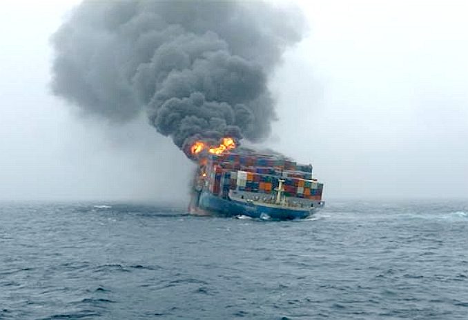
A derelict ship MV MOL Comfort caught fire today in Arabian sea, 310 nautical miles from Mumbai coast, while it was being towed by tugs.
The ship had broken into two parts on June 17, and one of the derelict parts was being tugged by a salvage company, when it caught fire, Coast Guard sources said.
The fire was noticed by Indian Coast Guard's Dornier aircraft at 11 am on Saturday while on routine maritime surveillance mission. It was bound for Port Sohar, Oman.
The ill-fated vessel broke into two on June 17 and all 26 crew on board were saved by Maritime rescue co-ordination c3ntre, Mumbai.
Indian Coast Guard ship Samudra Prahari on patrol has been diverted to monitor the situation and render assistance.
The vessel was carrying harmful chemicals in containers and it broke into two parts near Yemen coast, 840 nautical miles from
Mumbai.
SHARE
THIS PAGE: TWEET
LINKS
& REFERENCE
Indiatvnews
cement carrier sinks in Arabian Sea with 14 crew rescued India
TV news major fire in ship MV MOL Comfort off Mumbai sea coast Maritime
connector news environment technology Arabian Sea threatened by silent oil
spills NOAA
press_release
humpback whales 2011 PLOS
journal.pone Wikipedia
Arabian_Sea Marine
Insight
reasons-behind-the-collision-of-cargo-vessels-msc-chitra-and-khalijia Daily
Maill
news pictures container ship collision sends 2 tons oil pouring Arabian
Sea hour http://www.iucn.org/about/union/secretariat/offices/asia/asia_where_work/pakistan/ http://www.theguardian.com/world/2003/aug/15/pakistan.oilspills https://docs.unocha.org/sites/dms/Documents/Pakistan.pdf http://pgfa.org/Articles/The_sad_state_of_Karachi_beaches/ http://kpt.gov.pk/ https://twitter.com/AmarGuriro https://twitter.com/third_pole https://www.thethirdpole.net/2016/06/08/karachis-catastrophic-pollution-of-the-sea/ http://www.dailymail.co.uk/news/article-1301858/In-pictures-Container-ship-collision-sends-2-tons-oil-pouring-Arabian-sea-hour.html http://www.marineinsight.com/marine/reasons-behind-the-collision-of-cargo-vessels-msc-chitra-and-khalijia/ http://www.indiatvnews.com/news/india/cement-carrier-sinks-in-arabian-sea-14-rescued-52010.html http://www.indiatvnews.com/news/india/major-fire-in-ship-mv-mol-comfort-off-mumbai-sea-coast-24706.html http://maritime-connector.com/news/environment-and-technology/arabian-sea-threatened-by-silent-oil-spills/ http://www.nefsc.noaa.gov/press_release/2011/SciSpot/SS1105/ http://dx.plos.org/10.1371/journal.pone.0114162 https://en.wikipedia.org/wiki/Arabian_Sea http://english.vov.vn/Culture/Dang-Thu-Thao-crowned-Miss-Vietnam-Ocean-2014/276894.vov http://www.talkvietnam.com/2014/02/miss-vietnam-ocean-2014-kicks-off-in-april/ http://www.hoahaudaiduongvietnam.com/ http://wordvietnam.com/your-say/tag/The%20Grand%20Beauty
http://wordvietnam.com/your-say/miss-ocean-vietnam-2014
ACIDIFICATION
- ADRIATIC
- ARCTIC
- ATLANTIC - BALTIC
- BAY BENGAL - BERING
- CARIBBEAN - CORAL - EAST
CHINA
ENGLISH CH
-
GOC - GULF
GUINEA - GULF
MEXICO
- HORMUZ - INDIAN
- IOC -
IRC - MEDITERRANEAN -
NORTH SEA - PACIFIC
- PERSIAN GULF
RED
SEA - SEA
JAPAN - STH
CHINA - PLASTIC
- PLANKTON - PLASTIC
OCEANS - SEA
LEVEL RISE - TAIWAN - UNCLOS
- UNEP
WOC
- WWF
AMAZON
- BURIGANGA - CITARUM - CONGO - CUYAHOGA
-
GANGES - IRTYSH
- JORDAN - LENA -
MANTANZA-RIACHUELO
MARILAO
- MEKONG - MISSISSIPPI - NIGER -
NILE - PARANA - PASIG - SARNO - THAMES
- YANGTZE - YAMUNA - YELLOW
|